Chapter 6. Trends in Selected Biomes, Habitats and Ecosystems: Inland Waters
Author:
Ned Gardiner, American Museum of Natural History
Contributor:
Ricardo Díaz-Delgado Hernández, Doñana Biological Research Station
Reviewers:
David Coates, Secretariat of the Convention on Biological Diversity
Ricardo Díaz-Delgado Hernández, Doñana Biological Research Station
Remote sensing based indicators for inland waters:
- Extent of large inland waters and wetlands
- Extent of inland waters below sensor detection limits
- Variability of water levels and extent
- Coupling biological and physical assessments
- Changes in habitat and ecosystem quality
6.1 Introduction
Earth’s wetlands provide priceless services to society. Wetlands deliver and cleanse fresh water, from headwater streams to receiving water bodies such as lakes, rivers, and oceans. Freshwater fisheries provide protein and food security to much of the world, especially for rural populations in developing countries where people have direct access to fishing waters and a large proportion of the catch is consumed locally with or without formal marketing arrangements (Coates 1995). Wetlands mitigate natural and anthropogenic processes. Headwater streams process nitrogen inputs from non-point sources very effectively; those smaller than 5m in width export only about half of the nitrogen inputs they receive (Peterson et al. 2001). Wetland vegetation also provides a physical barrier to storms. For example, mangroves buffered coastal areas of
Sumatra struck by the tsunami of December 26, 2004 (Danielsen et al. 2005). About 6 percent of Earth’s surface is covered by freshwater ecosystems. Within that 6 percent of Earth’s surface dwells much of the planet’s biodiversity. Species that use freshwater habitats are threatened at greater rates than other taxa (Ricciardi and Rasmussen 1999). Systematics and taxonomy are also incomplete in the freshwater realm. Only recently has a global database of amphibians and the threats they face been available . Freshwater fishes, which comprise approximately 30 percent of the planet’s vertebrate biodiversity, are not well described. Hundreds of new species are described annually; thus their distributions, threats, and life histories are inadequately understood. There is good reason to believe current numbers of imperilled taxa will increase in light of ongoing findings in systematics of freshwater species. Because of the importance and imperilment of these freshwater species, international attention has recently focused on protecting and managing both inland waters and wetlands.
6.1.1 Definition of inland waters Inland waters refers to lakes, streams, rivers and other bodies of water located within continental boundaries. The CBD supports the Ramsar definition and framework for delineating and protecting “wetlands”. That definition encompasses a very wide diversity of ecosystem types:
… areas of marsh, fen, peatland or water, whether natural or artificial, permanent or temporary, with water that is static or flowing, fresh, brackish or salt, including areas of marine water the depth of which at low tide does not exceed six metres… areas may incorporate riparian and coastal zones adjacent to the wetlands, and islands or bodies of marine water deeper than six metres at low tide lying within the wetlands .
This chapter addresses both inland waters and wetlands (collectively termed “freshwater systems”) because remote sensing and spatial analysis techniques used to study each inform one another and differ markedly from those used in terrestrial systems.
6.1.2 Feasibility of remotely sensed indicators for inland waters Their importance and imperilment underscore the need to map and monitor freshwater systems using remote sensing as well as data collected directly from wetland habitats. When asked about the feasibility of identifying, delineating, and monitoring wetlands on a global basis using Earth observing (EO) satellites, the Chair of the European Space Agency’s Earth Science Advisory Committee, Professor Hartmut Graßl, replied that global wetland monitoring is already possible, given the all-weather capability of synthetic aperture radars on ERS-1/2, Envisat and Radarsat-1 along with many available high spatial resolution optical sensors from several space agencies.
Graßl (2006) pointed out, however, that many nations do not yet have the requisite expertise, hardware, and software needed to analyse wetlands using remote sensing. The physical diversity of wetlands requires that earth-observing satellite systems acquire data in cloudy as well as cloud-free conditions, help distinguish vegetation types by stature and/or species in both dry and wet conditions, and offer repeated observations in order to characterize the dynamic changes inherent to hydrologically dominated systems. Given these different requirements, data from multiple satellite platforms and instruments must be employed.
High spatial resolution satellite and aerial data hold much promise for analysing wetlands. Data from the SPOT sensors launched and managed by Centre National d’Etudes Spatiales (CNES) provide panchromatic imagery of approximately 1-5 m resolution. Commercial EO data, such as from Quickbird and Orbview-3, offer panchromatic data with a nominal pixel resolution of approximately 1 metre. Aerial surveys also offer data at this resolution. In many cases, data acquired from aircraft platforms may be available, in which case many types of sensors may be considered. For example, hyperspectral optical imagery, light detecion and ranging (lidar), forward-looking infrared (flir), and side-looking airborne radar (SLAR) may be available to wetlands researchers via aerial platforms. However, because these types of data are both expensive and not globally available, they may not be practical for national-level assessments of freshwater ecosystems. The resolution limit of data available to government agencies and contractors at an affordable price is approximately 30 m.
Mapping freshwater systems and deriving biological indicators of species composition or ecosystem condition are conducted collaboratively and in parallel. The products of each set of analyses may be statistically related. Taken alone, however, operational wetland indicators via remote sensing are somewhat limited.
The objective of this chapter is to describe how freshwater systems can be delineated using moderate resolution remote sensing and to suggest ways to incorporate biophysical assessments into monitoring efforts. Static data sets provide baseline boundary information for identifying rivers, inland water bodies, and watersheds. Because wetlands are inherently dynamic due to intra-annual fluctuation of water inputs and outflows, time-series methods are used to characterize that hydrologic variability. The most rapid advances in remote sensing of wetlands coincide with direct collaboration between field scientists and remote sensing practitioners, especially when developing indicators of ecosystem integrity. In some cases, physical and biological assessments have been repeated through time, thus providing insight into the feasibility of operationally monitoring wetlands. These three themes (delineating wetlands globally using static representations, characterizing variability in the physical makeup of these systems, and collaboration between biodiversity and remote sensing scientists) present avenues and opportunities for linking wetland biodiversity to remotely sensed metrics.
6.2 Delineating extent
6.2.1 Global datasets Currently, there are two global databases of inland waters. The freely available Surface Water Body Database (Slater et al. 2006) provides boundaries for large water bodies globally constructed using elevation data from the Shuttle Radar Topography Mission (SRTM) in combination with optical imagery from Landsat. The Global Lakes and Wetlands Database (Lehner and Döll 2004) contains data at three coordinated levels on 1) large lakes and reservoirs, 2) smaller water bodies, and 3) wetlands. The input data include remote sensing products such as land cover (Birkett and Mason 1995; Loveland et al. 2000). High-resolution mapping has been carried out for a small number of countries or regions, but the lack of a common classification system has hindered integration of these results with other continental or global-scale datasets. Delineation and classification of vegetation from space have been demonstrated for a variety of wetland types (Atlantis Scientific 2002). However, several geographical features conspire against the operational use of EO satellites to map and monitor aquatic systems on a global basis. For one, despite the fact that water covers most of the planet, inland waters are sparsely distributed. Total global inland water area is between 8 and 10 million square kilometres, or 6.2-7.6 percent of total land area. Lakes and reservoirs cover much of about 2.7 million square kilometres, or 2 percent of global land area. Freshwater marshes and floodplains cover about 2 percent of Earth’s land. The vast majority of wetlands are small. Half are less than about 200 ha, and about 90 percent are probably smaller than a 15 km x 15 km area (Atlantis Scientific 2002). The size of aquatic ecosystems spans 12 orders of magnitude, from spring seeps on the order of 1 m2 (10-6 km2) to the Caspian Sea, whose area is 3.7 x 10⁵ km2. Wetlands that had been listed with the Ramsar Convention by 2002 ranged in size from 1 ha to 7 x 10⁶ ha (Atlantis Scientific 2002). Delineating wetland extent therefore requires data at all extents and resolutions as well as a diverse set of methods aimed at extracting relevant ecosystem parameters.
6.2.2 Regional or national scale The task of using remote sensing to inventory inland waters is non-trivial, but there are many Earth observation capabilities available that can be exploited more fully to assess wetlands (Melack 2004; Mertes et al. 2004). The following sections describe ways of delineating the extent of inland waters and wetlands. The first examples address those below detection limits of data commonly available through EO satellite platforms while the latter examples address large inundated areas or open water bodies that may be studied using EO satellites whose data are affordable to governments around the world.
6.2.2.1 Inland waters below detection limits Most smaller rivers are not directly detectable using data at or below the 30-m resolution threshold considered a practical limit for national assessments. Often, analysts turn to watershed analysis within geographic information systems (GIS) software. These methods use digital elevation model (DEM) data to infer the direction that water would flow if travelling overland and downhill from any point in a landscape (O’Callahan and Mark 1984). Once flow direction information has been extracted, it is possible to infer the total number of cells, and hence area, above every cell in a DEM. The GIS database may further include watershed and river attributes such as forested area, land use, river discharge at measured locations, resident species, important features such as dams, water withdrawal points, discharge points, or other information pertinent to hydrology or biodiversity of wetlands (Hutchinson 1989). These GIS methods provide a means for tracking physical and biological conditions in rivers and watersheds (See Case Study 6.1). HydroSHEDS (Hydrological data and maps based on SHuttle Elevation Derivatives at multiple Scales) represents waterbodies, waterways, watersheds, and surface hydrology on a near-global basis and at multiple resolutions (Lehner et al. 2006). The data were built from NASA’s SRTM (NASA 2005) data, which describe surface elevations for Earth’s land area lying between +/- 57 degrees latitude.
HydroSHEDS data may be downloaded free of charge. The goal of developing this database was to generate key data layers to support watershed analyses, hydrologic modelling, and freshwater conservation planning at previously inaccessible quality, resolution, and extent. The seamless coverage of HydroSHEDS makes this dataset useful for continental analyses because it eliminates the need to blend multiple data sources.
Case Study 6.1: Stream and Watershed Databases for Large Regions: Construction and Applications
Watershed boundary and river channel identification within a GIS can help delineate and describe river ecosystems, These methods are: 1) watershed classification based on watershed and stream morphometry, 2) hillslope-derived sediment modelling, and 3) relating watershed characteristics with biota in receiving waters (Gardiner 2002). The study area was an 8600 km2 region in western North Carolina (Figure 6.1) that included four watersheds: Little Tennessee, Tuckaseegee, Pigeon, and French Broad.
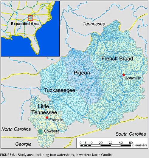
The backwater reaches of Lake Fontana define the watershed outlets for the Little Tennessee and Tuckaseegee River watersheds in this study. The North Carolina border with Tennessee defines the northern extent of the Pigeon and French Broad study areas. For every stream in this study area, watershed boundaries and river networks were extracted and defined. Road density, percent forested area in 1970, and percent forested area in 1993 were each measured above sampling locations using GIS analyses for each watershed between 10 and 40 km2 and with outlets between 550 and 720 m in elevation. Those data were submitted to cluster analysis (statistical classification methodology) to identify four distinct classes of watersheds: Undisturbed, Rural, Suburban, and Urban (Figure 6.2).
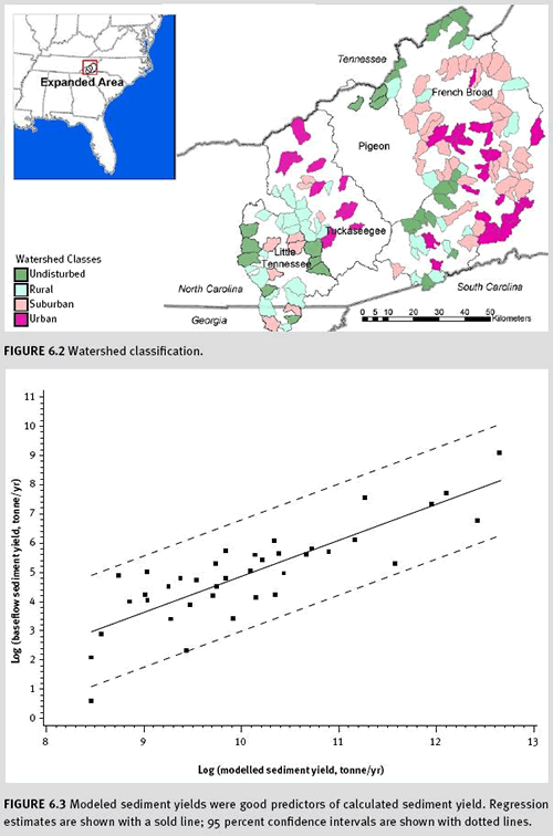
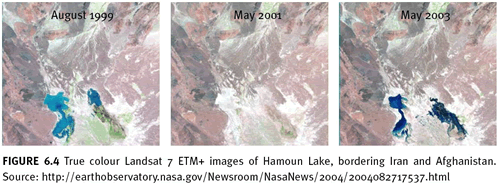
This classification scheme allowed stream ecologists to hypothesize where streams with similar conditions might be found within a large region. The watershed database provided focal study areas for a sediment model based on the Revised Universal Soil Loss Equation (Renard 1997). Land use and local slope each influence the amount of soil loss within a given cell, and each cell’s soil loss estimate was accumulated in the down-slope direction until it reached the stream channel. A sediment transport capacity function was used to limit the allowable mass of sediment moving through a given cell (Moore and Wilson 1992). This model proved effective at estimating annual sediment flux from entire watersheds (Figure 6.3). Further, these measures of sediment loading helped to predict the proportion of endemic fishes found within samples throughout the study area (see Scott and Helfman 2001). Watershed boundaries and river network data provided the framework for watershed classification and evaluation of land use effects on stream ecosystems across a large region. By examining the broad landscape, water resource professionals will increase their understanding of land use effects on water quality and ecological integrity.
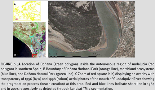
Large areas that are inundated may be directly mapped using remote sensing. A simple means of evaluating the areal extent of water is to analyse near infrared reflectance in a passive optical image because water absorbs most infrared energy, generating strong contrast with surrounding landscape features that reflect infrared wavelengths (Figure 6.4).
While rapid, deriving boundaries for inundated areas requires careful editing to ensure good results. Passive optical imagery is neither effective for delineating water beneath a closed canopy nor in cloudy conditions that are perennial throughout much of the tropics. The limitations of passive optical imagery have promoted radio detection and ranging (radar) technology as a rapid means of discerning open water since the wavelengths used are long enough to penetrate clouds, haze, and vegetation. Radar also provides unique information about surface texture and reflective properties. Radar can effectively discriminate open water, inundated vegetation, and vegetation on dry land. Though radar data analysis expertise is not as common as optical remote sensing techniques, radar is indispensible to wetland delineation and monitoring. A challenge of analysing radar data is how to properly interpret single-, double-, and multiple-return signals received at the sensor. Direct collaboration between vegetation scientists and remote sensing specialists brings both perspectives to the interpretation process. Working collaboratively with experts familiar with vegetation present on the ground at Mer Bleue, Atlantis Scientific (2002) used a Van Zyl (1989) classification algorithm to attribute single- vs. multiple-return signals to distinct vegetation life forms, such as herbaceous, emergent, shrub, and tree. Pilot studies conducted by the Treaty Enforcement Services using Earth Observation (TESEO) programme of the European Space Agency (Atlantis Scientific 2002) demonstrated the joint capabilities of both passive optical and active radar remote sensing for delineating and identifying wetland vegetation and other features at three Ramsar sites: Mer Bleue, Canada; Doñana, Spain; and Djoudj, Senegal. Their study of the Mer Bleue wetland in Ottowa, Canada utilized Landsat 7 ETM+ data as well as multi-date, multi-polarization C-band synthetic aperture radar data from both Envisat’s ASAR sensor and Radarsat-2. Landsat data were used to map several vegetation classes. Radar data provided locations of tree stems emerging from inundated areas. The optical, Landsat data helped distinguish species associations, which were themselves identified through collaboration between remote sensing professionals and vegetation scientists. Radar data provided direct evidence for the location and extent of inundated areas and emergent vegetation. The work begun by TESEO has continued, now under the auspices of GlobWetland, which itself is funded by the European Space Agency to study 17 sites around the world. Methods implemented by GlobWetland build on a body of knowledge pioneered by TESEO at Ramsar sites, but a separate effort in the Amazon (Melack 2004) provided concordant recommendations. Each of these research efforts concurs that multiple polarizations of radar data are essential to differentiate vegetation types and inundated vs. non-inundated forests. Given the utility, availability, and familiarity of optical remote sensing data (see Case Study 6.2) and the discriminatory power of radar to detect surface conditions below tree canopies as well as clouds, it is clear that multiple data types and sources must be used to effectively map wetland vegetation (Atlantis Scientific 2002).
Case Study 6.2: Remote monitoring of biodiversity at Doñana National Park
Author: Ricardo Díaz-Delgado Hernández
Established in 1968, Doñana National Park (537 km2) is both a Biosphere Reserve and a Ramsar Site. It contains the largest wetland in Europe, a complex matrix of marshlands (273 km2), phreatic lagoons, a 25 km-long dune ecosystem, and representative Mediterranean terrestrial plant communities (Figures 6.5a and 6.5b). Conservation objectives include the preservation of critically endangered species (Iberian Lynx, Imperial Eagle), waterfowl, and representative Mediterranean wetlands and terrestrial ecosystems. Doñana is both a critical stopover site for Palearctic birds migrating to Africa and an important overwintering site for waterfowl. Remote sensing has been used as a monitoring tool for Doñana ecosystems since 2002; images are being used to monitor:
- Shoreline and dune system dynamics
- Sedimentation processes in the marshland
- Terrestrial and marshland plant community changes
- Temporal patterns of marsh inundation and water turbidity
- Monitoring progress with ecological restoration of transformed marsh areas
- Land use and land cover changes in the vicinity of Doñana National Park.
A time series of co-registered and calibrated Landsat satellites images (MSS, TM and ETM+), regularly updated through a Landsat-5 TM subscription and many Landsat 7 ETM+ SLC-off scenes, provides a record spanning over 30 years (1975-2007). Semi-automated image texture and brightness analyses of ETM+ middle infrared (band 7) data distinguish sand from other land cover (such as water and pine forests), thus providing dune and shoreline boundaries. By comparing scenes from the last 23 years, we have observed that the most active dunes have advanced approximately 6 m/yr. In the south of the Park, the beach has advanced up to 18 m/yr, though the increase is not evenly distributed across beach front areas (Figure 6.5c). Sedimentation rates have increased in the watershed of the marsh in the last decade. Marsh restoration initiatives aim to reduce this trend.
In recent decades, land cover conversion and overgrazing have changed inundation patterns and thus susceptibility to drought. We use supervised classification to map both shrublands and marshland vegetation. Field observations from sampling plots, established as training areas where forest and shrubland stand structure are measured on the ground, have corroborated seedling mortality assessments following recent droughts. Episodic droughts require joint monitoring via remote sensing and ground-based observations.
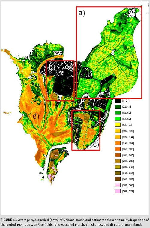
Research focused on discriminating inundation levels, turbidity, and depth using multi- and hyperspectral imagery has enabled us to reconstruct a historical profile of the inundation regime of Doñana marshes. Hydroperiod (the time during which a wetland is covered with water) values for every pixel have been calculated from inundation maps generated through simple thresholding of TM and ETM+ bands 5 (MSS band 4); this near infrared band is the best indicator of water level in shallow wetlands (Díaz-Delgado et al. 2006a). Hydroperiod helps researchers develop a greater understanding of plant presence, abundance, and inundation trends that may be human- or naturally induced (Díaz-Delgado et al. 2006b; Figure 6.6).
A large restoration project called “Doñana 2005” was initiated after a toxic spill from a local mine in April 1998 that severely compromised water quantity and quality entering Doñana marshes (Pain et al. 1998). Multispectral images together with airborne campaigns of the Airborne Hyperspectral Scanner (AHS) tracked the effectiveness of restoration efforts that promoted the return of natural species assemblages and the recovery of natural processes. All information generated from remote sensing is accessible through the worldwide web, allowing easy access and use of monitoring results. Two websites are available to visualize and download data: http://www-rbd.ebd.csic.es/Seguimiento/seguimiento.htm: results for all monitoring topics and methodological protocols. http://mercurio.ebd.csic.es/seguimiento/: web map server showing the location of all the ground sampling plots and providing results in a spatial context.
The frequent revisit time of Landsat (16 days for either ETM+ or TM but only 7 days using both in combination) has proved sufficient for our purposes. The 30m pixels of Landsat have been sufficient for landscape monitoring at Doñana. However, the spectral sensitivity of Landsat is insufficient for monitoring species assemblages. To discern dominant plant abundance among 8 species of shrub, we are using hyperspectral airborne sensors and Spectral Unmixing Analysis (Jiménez et al. 2007).
6.2.2.3 Mapping variability of water levels and extent Data acquired at high- and low-water are needed to accurately map wetland extent because these ecosystems are defined by water level fluctuation and function differently at different water levels (see Case Study 6.2). The acquisition time of archived data may be compared to the best-known stage information for a given area in order to choose imagery that will be of most use for characterizing high- and low-water regimes of the targeted ecosystem. For upland wetlands, antecedent soil moisture and precipitation affect river discharge, wetland extent, and surface water levels and therefore influence the optimal date for acquiring imagery. The situation is more complex for seasonally inundated systems that receive water input from rivers because river flood stage and peak flow are influenced by upstream, catchment-wide hydrological factors that delay peak discharge relative to peak precipitation events. Temperate rivers reach bank full stage with a recurrence interval of between 1.5 and 2.5 years, suggesting that optimal data for analysis might appropriately come from different years in order to capture both low- and high-water events within the data record for a site. Mapping the high- and low-water stages of rivers with active floodplain systems, such as the Amazon, is important since the function of these systems is defined relative to that variation in water level and extent.
The behavior, function, and aerial extent of wetlands changes through time, so characterizing changes in habitat quality requires a thorough understanding of natural variability. Water and nutrients are transported from headwaters to downstream river ecosystems, but there is a bidirectional interaction of rivers with active floodplains. Nutrient flux from floodplains into river food webs is an important linkage between rivers and the floodplain habitat associated with them. When researchers first mapped and compared the extent of floodplain inundation at high- and low-water levels, they surmised that the mass of carbon emitted from rivers in the form of CO2 during high water stages throughout the year was comparable in magnitude to the amount of carbon transported down river (see Melack 2004). Thus, accurate mapping at high- and low-water levels has led to significant new insights into the structure and function of aquatic systems.
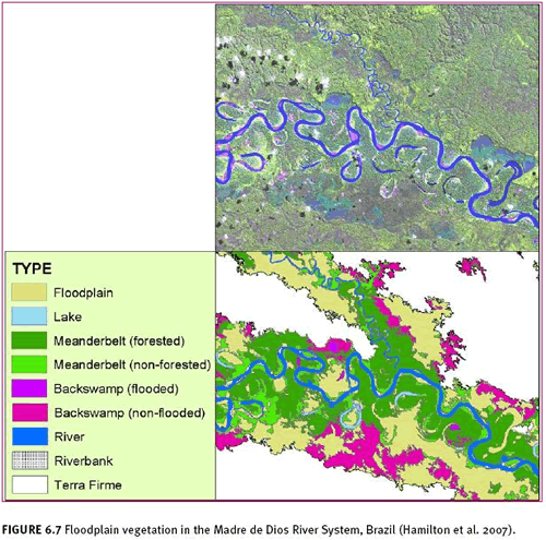
Recent remote sensing efforts have demonstrated how to map floodplain forests using a variety of satellite sensors and data available at multiple resolutions. Hamilton and colleagues (2007) used remotely sensed data in combination with HydroSHEDS river network data to characterize wetlands in floodplains of the Madre de Dios River. They mapped floodplains, standing water, and vegetation associated with unique geomorphic settings in this flood-dominated ecosystem (see Figure 6.7). This research employed object-oriented, contextual classification, a set of techniques that utilizes the spatial setting of landscape features to help identify and classify imagery. Image data included Landsat 7 ETM+ data, elevation profiles from NASA’s SRTM, and JERS-1 L-band radar scatterometer mosaics. The Landsat and SRTM data were stacked and subsequently divided into clusters of pixels. Landsat data and JERS-1 mosaics were used to classify image clusters describing small features, such as individual meander bends. At a coarse scale, SRTM elevation data successfully distinguished uplands from floodplains. Their hierarchical, multi-scale analysis combined the unique capabilities of optical and radar data to extract vegetation classes and geomorphic types. Both vegetation and geomorphic features were further related to hydroperiod, with water and vegetation features closer to the river showing chemical and hydrologic influences from the river while features set back into the floodplain were more influenced by groundwater than by the river. Those biogeochemical classifications were determined and verified through ground surveys and laboratory analyses. This study demonstrates the capabilities of modern remote sensing image processing when applied to DEM, optical, and radar data. In situ data enhanced the authors’ ability to delineate ecologically relevant features of a flood-pulse dominated landscape.
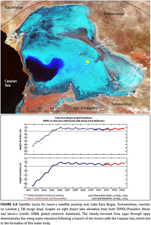
If a water body is between 0.5 and 1.0 km in width or 100-300 km2 in area, satellite-based radar altimeters may be used to monitor their water levels (Mertes et al. 2004). That size restriction eliminates about 90 percent of Ramsar sites (Atlantis Scientific 2002), but for large, open water bodies, this technology has proven highly valuable. It is being used operationally by the United States Department of Agriculture (USDA) Foreign Agriculture Service (FAS) to monitor water supply throughout the world (Figure 6.8) .
The 2002 TESEO study (Atlantis Scientific 2002) emphasized that C-SAR data were effective in identifying the varying extent of wetlands through wet and dry seasons. Inundated areas with no vegetation scattered radar signals but did not reflect them back to the sensor. Thus, water areas appeared dark in resultant imagery. This principle underlies the use of radar for delineating the extent of open water. Where emergent vegetation was present, some backscatter was evident. This physical property allows analysts to clearly identify inundated vegetation. Employing these principles, the TESEO study mapped seasonal wetland variability. In spring, there were wide expanses of open water and flooded vegetation whose area decreased through the dry summer and early fall; in October 1995, wetland extent increased once again. This ability to monitor the seasonal changes in extent of open water and flooded vegetation is useful for characterizing wetland responses to varying hydrologic periods.
6.2.2.4 Coupling biological and physical assessments To evaluate in situ biological and physical properties of river ecosystems, researchers often use “multimetric” indicators, statistical descriptions that simultaneously describe a site’s species and local habitat relative to undisturbed sites with similar landscape settings. Multimetric indicators are derived empirically from a set of sites or through time, for example from density or relative proportion of taxa collected at a site or group of sites. The categories and point assignments used to derive multimetric scoring systems must be calibrated to the fishes, macroinvertebrates, or microbes found in streams and rivers within a bioregion, so this work is conducted by a biologist with the requisite expertise in regional fauna and flora. Fish and invertebrate ecologists have the most experience using multimetrics to describe and categorize ecosystem health in rivers and streams, but taxonomists and ecologists are studying how to develop indicators of stream health that focus on the microbes found at a stream sampling site. Multimetric scores can be compared statistically to land use data derived from remote sensing and extracted on a watershed basis using GIS software. This statistical approach guides inferences about the effect of watershed practices on streams or rivers. This procedure is widely practiced but should be conducted only through direct collaboration among experts in GIS, remote sensing, and freshwater biology.
Large rivers, lakes, reservoirs, and estuaries provide sufficient surface area for direct detection by space-based sensors of water and water quality parameters that are sensitive to catchment-wide land use changes as well as internal physical, chemical, and biological dynamics. Direct detection and satellite-based modelling of primary productivity in large lakes has been feasible for several decades (Dekker and Seyhan 1988, Dekker et al. 1991, 1992a, 1992b, Dekker and Peters 1993). Two low-resolution sensors, MODIS and SeaWifs, have operational chlorophyll detection algorithms that exploit the high reflectivity of phytoplankton in infrared wavelengths. Hyperspectral technologies have also been used to study primary productivity of inland waters (Hoogenboom et al. 1998), although these studies focus on very small areas and use data not available on a global basis. Optical data are also used to estimate suspended solids concentrations in large water bodies (Dekker et al. 2001).
6.3 Changes in habitat and ecosystem quality
Change and variability are inherent to the structure and functioning of wetlands. Just as one may assess the natural variability of water extent, exogenous inputs, and biota within wetlands, it is possible to measure long-term trends and changes to wetlands using the same or similar methods. Some changes to wetlands can be evaluated somewhat directly, for example the influence of land cover change on the timing and delivery of water and suspended constituents to rivers, or the effect of global warming on boreal wetlands. This section focuses on watershed-based, optical, and radar-based monitoring of wetlands that are undergoing anthropogenic change.
6.3.1 Rivers and watersheds Land cover change upstream of receiving waters alters the hydrologic, nutrient, and physical templates of those ecosystems. When forested catchments are clear-cut in temperate forest ecosystems, recovery of some parameters, such as nutrient retention and turnover, requires up to several years to re-establish pre-disturbance regimes. Other physical characteristics require decades for recovery. For example, sediment delivered to rivers and streams following a major disturbance, such as watershed-wide clear-cutting, may require infrequent, episodic torrential rain events in order to generate sufficient hydrologic power to redistribute large quantities of sediment downstream. Once vegetation recovers, the legacy of historic deforestation events can therefore have a very long-lasting impact on the habitat template of stream ecosystems.
In addition to characterizing ongoing changes to streams through monitoring catchment-wide land cover change, understanding wetlands requires that one document and understand the historic changes that have occurred in that ecosystem’s watershed. The methods for characterizing hydrologic processes, and therefore the integrity of flowing water ecosystems, hinge on accurate delineation of land cover and historic land cover throughout a watershed. Specific techniques for analysing land cover are addressed throughout this volume. Given adequate land cover data for key dates, for example before and after major land use changes, it is possible to quantitatively estimate changes to hydrologic regimes or loadings of constituents that alter habitat quality, such as sediment, nutrients, and trace elements. As with the assessments described previously (e.g., Case Study 6.1), the relationships between watershed conditions and river discharge, loadings, and concomitant habitat quality must be calibrated based on knowledge of regional conditions.
Spatial data describing regional climate patterns, physiography, land cover, and land use lend insight into how to manage watersheds. Conservation planners prioritize their effort using the best available data describing a region of interest. Often, data describing biodiversity are absent, so planning must move forward in the absence of biological information using surrogate measures such as climate information. Planners and researchers from WWF-US, Michigan State University, Woods Hole Research Center, and WWF-Peru recently prioritized conservation recommendations for a 160,000 km2 headwater region of the Madre de Dios and Orthon rivers in Peru (Thieme et al. 2007). Each river is a tributary of the Amazon River, and the study area as a whole is within the southwestern Amazonian Moist Forests ecoregion of the Global 200 priority regions identified by Olson and Dinerstein (1998). The work used GIS-based analyses of terrain, vegetation, and existing protected areas to recommend areas for conservation attention. The study’s authors hope the work will prevent problems arising from road building and other land-clearing activities that are likely to accompany oil and gas exploration in the region. Activities such as these will remove vegetation and expose soil, thereby increasing sediment delivery to waterways through erosion and transport of disturbed soil. Sedimentation is among the most common processes that degrade river ecosystems. GIS data describing watershed boundaries, stream channels, and watershed morphometry provided requisite data for evaluating potential discharge along stream segments, percentage of watershed area found within the Andes, and connectedness of river segments among protected areas that have already been identified. Watershed-based analyses, such as those conducted in the Madre de Dios River basin, are an essential component of evaluating the potential influence of land use decisions on wetlands.
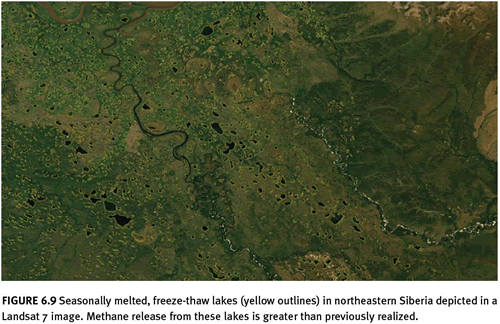
6.3.2 Ecosystem structure and function Remote sensing analyses complement campaigns focused on the structure and function of wetland ecosystems. For example, due to changes in freeze-thaw cycles and permafrost conditions stemming from global warming, there is increasing attention and interest in greenhouse gas emissions from boreal forests. Approximately 25 percent of the carbon that is bound within terrestrial ecosystems is likely found in high-latitude peat lands (Hess and Melack 1994). When they dry out, peat lands respire CO2 and CH4 into the atmosphere, so monitoring inundation in these areas is important for quantifying greenhouse gas emissions from peat lands. In boreal Siberia and eastern Canada, Gorham (1991) posited that satellite data may be used to monitor the declining area of open water as an indicator of global warming effects on peat land ecosystems, but that effort also requires contribution from biogeochemists with expertise in quantifying and evaluating outgassing. Conversely, biogeochemists recently estimated that methane emissions from seasonally melted lakes in permafrost regions of Siberia may contribute about twice as much CH4 to the atmosphere as previously thought (Walter et al. 2006). Their estimates were based on field-collected samples from a handful of lakes, and results were extrapolated based on estimates using GIS and remote sensing (Figure 6.9). Kimball and colleagues (2006) have used microwave data to show that seasonality has changed in recent decades, with warm temperatures arriving earlier in the year and cold temperatures arriving later.
The examples provided demonstrate the feasibility of using remote sensing indicators to measure natural variability in wetland extent. Coordinated field campaigns and remote sensing research can yield statistically rigorous relationships between remote sensing indicators and biophysical characteristics of wetland ecosystems. For rivers below the detection limits of remote sensing, watershed modelling within GIS software utilizes remotely sensed land cover information to derive hydrologic and suspended loading information that can be used to infer habitat quality parameters. Larger water bodies may be directly mapped, both in terms of aerial extent and water elevation.
6.4 Summary of the use of satellite data for operational monitoring
The most promising avenues for developing remote sensing indicators for riverine ecosystems that are below the direct detection limits of satellites are: 1) watershed classification, which incorporates GIS data and remote sensing measures of land cover and land use, and 2) developing statistical relationships between biota and watershed or river reach descriptions stored within a GIS and derived from both GIS data and remote sensing. Remotely sensed observations may be used effectively to delineate wetland ecosystems; data interpretation requires expertise in ecosystem assessment. Ecologists familiar with a given site can greatly enhance the ability of remote sensing analysts to extract meaningful map products from satellite-derived data.
Mapping wetlands around the world has previously been conducted at low resolution; within 1-degree cells, inundated area was estimated to provide some idea of greenhouse gas emissions from five types of wetlands (Matthews and Fung 1987). Mapping at higher resolution will require both optical and radar sensor systems. Countries seeking to delineate freshwater systems rely on data available through government agencies and government purchase agreements. The one- to two-day repeat interval offered by low-resolution optical sensors, such as MERIS or MODIS, offers imaging data of particular use in areas not obstructed by clouds and for large water bodies. The medium resolution capabilities of NASA’s Landsat series of instruments and CNES’ SPOT instruments offer resolution between 30 m and 5 m and therefore reveal more detail about smaller water bodies and seasonally inundated areas. Canada Space Agency’s synthetic aperture radar (SAR) data are an important resource for mapping wetlands globally. Radarsat-1 provided HH-polarization only, while Radarsat-2 provides both single- and dual-polarization. Radarsat-2 can provide SAR data at a resolution of up to 3 m.
A variety of researchers (see Melack 2004 and references therein) and demonstration projects (see Mer Bleue studies by Atlantis Scientific 2002) have found that C-band radar can be used to measure seasonal changes in inundation of vegetation, even for low-stature grasses and forbs. The VV polarization of C-band radar data has been shown to be sensitive to the density of rice in fields as well as natural wetland, non-woody vegetation. The longer wavelength, L-band of radar penetrates the more dense canopies of forests and therefore can distinguish flooded and non-flooded forest vegetation. C-band SAR is a promising sensor type for monitoring seasonal changes in flooded vegetation. Polarimetric C-band SAR can discriminate major classes of vegetation, such as herbaceous cover, shrubs, and forests. Radar altimetry and interferometry hold promise for measuring subtle elevation changes in peat bogs and may provide an indication of annual vegetation growth. HH polarization distinguishes inundated vegetation from dry vegetation and from water due to backscatter characteristics of each of these feature types.
6.5 Data and other resources
HydroSHEDS HydroSHEDS promises near-global river drainage information at multiple resolutions.
Surface Water Database from NASA/JPL
Acknowledgments This paper was stimulated by a workshop hosted April 6, 2005 by the American Museum of Natural History’s Center for Biodiversity and Conservation through support from NASA under grant NNG04GC18G. Some research cited here was funded by NSF Grant DEB96-32854 to the Office of the Vice President for Research at the University of Georgia, and NASA grant NAG5-6479 to the University of Georgia. Laura Hess provided crucial insight into the operational use of radar data. The case study for Doñana was funded by Doñana National Park administration (Spanish Ministry of Environment) through the research project “Reconstruction of bird population dynamics during the last three decades” and by the Spanish Ministry of Science and Education through the research project HYDRA (# CGL2006-02247/BOS). Doñana National Park and Natural Park provided permits for field work in protected areas with restricted access. A. Travaini, H. Le Franc, D. Paz, A. Polvorinos, and I. Román helped with field work. J.C. Gilabert, J.L. Pecharromán and P.L. Porta helped with image processing.
6.6 References
Atlantis Scientific, Inc. 2002. Treaty Enforcement Services Using Earth Observation: Wetlands Monitoring. ESRIN Contract No. 15461/01/1-LG. Final Report Submitted to ESRIN Contracts Service.
Birkett, C.M., Mason, I.M. 1995 A new global lakes database for a remote sensing program studying climatically sensitive large lakes. Journal of Great Lakes Research 21(3): 307-318.
Bustamante, J., F. Pacios, R. Diaz-Delgado, and D. Arangonés. In Press. Predictive models of turbidity and water depth in the Doñana marshes using Landsat TM and ETM+ images. Journal of Environmental Management.
Coates, D. 1995. Inland capture fisheries and enhancement: status, constraints, and prospects for food security. In, International Conference on Sustainable Contribution of Fisheries to Food Security. Kyoto, Japan: Government of Japan and FAO, Rome, Italy.
Danielsen, F., M.K. Sørensen, M.F. Olwig, V. Selvam, F. Parish, N.D. Burgess, T. Hiraishi, V.M. Karunagaran, M.S. Rasmussen, L.B. Hansen, A. Quarto, and N. Suryadiputra. 2005. The Asian Tsunami: A Protective Role for Coastal Vegetation. Science 310 (3748): 643.
Dekker, A. G., T. J. Malthus, and E. Seyhan. 1991. Quantitative Modeling of Inland Water-Quality For High-Resolution MSS Systems. IEEE Transactions on Geoscience and Remote Sensing 29:89-95.
Dekker, A. G., T. J. Malthus, M. M. Wijnen, and E. Seyhan. 1992a. The Effect of Spectral Bandwidth and Positioning on the Spectral Signature Analysis of Inland Waters. Remote Sensing of Environment 41:211-225.
Dekker, A. G., T. J. Malthus, M. M. Wijnen, and E. Seyhan. 1992b. Remote-Sensing as a Tool For Assessing Water-Quality In Loosdrecht Lakes. Hydrobiologia 233:137-159.
Dekker, A. G., and S. W. M. Peters. 1993. The Use of the Thematic Mapper for the Analysis of Eutrophic Lakes – A Case-Study in The Netherlands. International Journal of Remote Sensing 14:799-821.
Dekker, A. G., and E. Seyhan. 1988. The Remote-Sensing Loosdrecht Lakes Project. International Journal of Remote Sensing 9:1761-1773.
Dekker, A. G., R. J. Vos, and S. W. M. Peters. 2001. Comparison of remote sensing data, model results and in situ data for total suspended matter (TSM) in the southern
Frisian lakes. Science of the Total Environment 268:197-214.
Díaz-Delgado, R., Bustamante, J., Aragonés, D. and Pacios, F. 2006a. Determining water body characteristics of Doñana shallow marshes through remote sensing. In Proceedings of the 2006 IEEE International Geoscience & Remote Sensing Symposium & 27th Canadian Symposium on Remote Sensing (IGARSS2006), organized by the Geoscience and Remote Sensing Society. Denver, Colorado, USA, 31 July-4 August 2006. Pages: 3662-3664.
Díaz-Delgado, R., Bustamante, J., Pacios, F. and Aragonés, D. 2006b. Hydroperiod of Doñana marshes: natural or anthropic origin of inundation regime? In Proceedings of the 1st GlobWetland Symposium, organized by ESA and Ramsar Convention. Frascatti, Italy, 19-20 October.Gardiner, E.P. 2002. Geospatial Techniques for Stream Research in the Southern Blue Ridge Mountains. Ph.D. Dissertation. University of Georgia, Athens.
Gardiner, E.P. 2002. Geospatial techniques for stream research in the southern Blue Ridge Mountains. Ph.D. Dissertation. Athens: University of Georgia
Gorham, E. 1991. Northern Peatlands – role in the carbon cycle and probable responses to climatic warming. Ecological Applications, 1, 182-195.
Hamilton, S.K., J. Kellndorfer, B. Lehner, and M. Tobler. 2007. Remote sensing of floodplain geomorphology as a surrogate for biodiversity in a tropical river system (Madre de Dios, Peru). Geomorphology.
Hess, L.L. and Melack, J.M. 1994. Mapping wetland hydrology and vegetation with synthetic aperture radar. International Journal of Ecological and Environmental Science 20:197-205.
Hoogenboom, H. J., A. G. Dekker, and I. A. Althuis. 1998. Simulation of AVIRIS sensitivity for detecting chlorophyll over coastal and inland waters. Remote Sensing of Environment 65:333-340.
Hutchinson, M.F. 1989. A new procedure for gridding elevation and stream line data with automatic removal of spurious pits. Journal of Hydrology, 106, 211-232
Jiménez, M., Díaz-Delgado, R., Vaughan, P., Fernández-Renau, A., Gutiérrez, O. and Prado, E. 2007. Airborne Hyperspectral Scanner (AHS) a priori mapping capacity for the Doñana Biological Reserve shrublands. Proceedings of the 10th International Symposium on Physical Measurements and Signatures in Remote Sensing. Organized by International Society for Photogrammetry and Remote Sensing. Davos, Switzerland, 12-14 March. page 80.
Junk, W.J., Bayley, P.B., & Sparks, R.E. 1989. The flood pulse concept in river-floodplain systems. In D.P. Dodge (Ed.), Proceedings of the International Large River Symposium. Canadian Special Publication in Fisheries and Aquatic Sciences. pp. 110-127
Kimball, J.S., McDonald, K.C., & Zhao, M. 2006. Terrestrial vegetation productivity in the western arctic observed from satellite microwave and optical remote sensing. Earth Interactions 10, 22.
Lehner, B., K. Verdin, A. Jarvis. 2006. HydroSHEDS Technical Documentation, Version 1.0.
http://gisdata.usgs.net/HydroSHEDS/downloads/HydroSHEDS_TechDoc_v10.pdf
Lehner, B. and P. Döll 2004: Development and validation of a global database of lakes, reservoirs and wetlands. Journal of Hydrology 296/1-4: 1-22.
Loveland, T.R., Reed, B.C., Brown, J.F., Ohlen, D.O., Zhu, J, Yang, L., and Merchant, J.W. 2000: Development of a global land cover characteristics database and IGBP DISCover from 1-km AVHRR data. International Journal of Remote Sensing 21(6/7): 1303–1330.
Matthews, E. and I. Fung. 1987. Methane emissions from natural wetlands: Global distribution, area, and environmental characteristics of sources. Global Biogeochemical Cycles 1: 61-86.
Melack, J.M. 2004. Remote sensing of tropical wetlands in S. Ustin, editor. Manual of Remote Sensing, 3rd edition. Remote Sensing for Natural Resources Management and Environmental Monitoring. 3 ed., Vol. 4. John Wiley & Sons, New York. Pages 319-343.
Mertes, L.A.K., A.G. Dekker, G.R. Brakenridge, C.M. Birkett, G. Létourneau. 2004. Rivers and lakes in S. Ustin, editor. Remote Sensing for Natural Resources Management and Environmental Monitoring: Manual of Remote Sensing, 3 ed., Vol. 4. John Wiley & Sons, Inc. 345-400.
Moore, I.D., & Wilson, J.P. 1992. Length-slope factors for the revised universal soil loss equation: simplified method of estimation. Journal of Soil & Water Conservation 47, 423-428.
O’Callaghan, J.F., & Mark, D.M. 1984. The extraction of drainage networks from digial elevation data. Computer Vision, Graphics and Image Processing, 28, 323-344.
Olsen, D.M. and E. Dinerstein. 1998. The Global 200: a representative approach to conserving the Earth’s most biologically valuable ecoregions. Conservation Biology 12: 502–515.
Pain, D.J., Sánchez, A., & Meharg, A.A. 1998. The Doñana ecological disaster: contamination of a word heritage estuarine marsh ecosystem with acidified pyrite mine waste. The Science of the Total Environment, 222, 45-54
Peterson, B. J., W. M. Wollheim, P. J. Mulholland, J. R. Webster, J. L. Meyer, J. L. Tank, E. Marti, W. B. Bowden, H. M. Valett, A. E. Hershey, W. H. McDowell, W. K. Dodds, S. K. Hamilton, S. Gregory, and D. D. Morrall. 2001. Control of Nitrogen Export from Watersheds by Headwater Streams. Science 292:86-90.
Renard, K.G. 1997. Predicting Soil Erosion by Water: A Guide to Conservation Planning with the Revised Universal Soil Loss Equation (RUSLE). USDA Agricultural Research Service Agriculture Report 703.
Ricciardi, A. and J.B. Rasmussen. 1999. Extinction rates of North American freshwater fauna. Conservation Biology 13 (5): 1220-1222.
Scott, M.C., & Helfman, G.S. 2001. Native invasions, homogenization, and the mismeasure of integrity of fish assemblages. Fisheries, 26, 6-15.
Slater, J.A., G. Garvey, C. Johnston, J. Haase, B. Heady, G. Kroenung, and J. Little. 2006. The SRTM data “finishing” process and products. Photogrammetric Engineering and Remote Sensing 72:237-247.
Thieme, M., B. Lehner, R. Abell, S.K. Hamilton, J. Kellndorfer, G. Powell, and J.C. Riveros. 2007. Freshwater conservation planning in data-poor areas: an example from a remote Amazonian basin (Madre de Dios River, Peru and Bolivia). Biological Conservation 135: 500-517.
Van Zyl, J. 1989. Unsupervised classification of scattering behavior using radar polarimetry data, IEEE Transactions on Geoscience and Remote Sensing 27(1):36-45.
Walter, K.M., S.A. Zimov, J.P. Chanton, D. Verbyla, and F.S. Chapin III. 2006. Methane bubbling from Siberian thaw lakes as a positive feedback to climate warming. Nature 443(7): 71-75.