Chapter 2. Remote Sensing and monitoring for the Convention on Biological Diversity
Authors: Holly Strand, World Wildlife Fund (WWF-US) and Utah State University
Eugene Fosnight, UNEP/GRID-Sioux Falls
Peter Herkenrath, UNEP World Conservation Monitoring Centre
Robert Höft, Secretariat of the Convention on Biological Diversity
Contributors: Woody Turner, NASA Headquarters
Valerie Kapos, UNEP World Conservation Monitoring Centre
Eric Sanderson, Wildlife Conservation Society
2.1 The 2010 biodiversity target framework: Focal areas, goals, and subtargets
The 2010 biodiversity target is the keystone of the Strategic Plan of the
Convention on Biological Diversity (CBD) adopted in 2002. The target is associated with seven focal areas designed to enhance the evaluation of progress in implementation. These focal areas represent the broad remit of the Convention, including not only issues of conservation and sustainable use of biodiversity, but also social considerations dependent upon the maintenance and use of biodiversity. Within each focal area, a provisional set of goals and subtargets helps clarify and assess progress toward the target, as well as promote coherence among the Programmes of Work of the Convention. Beyond its global application, this structure forms a flexible framework within which national or regional subtargets or both may be developed, according to priorities and capacities at these scales and taking into account differences in diversity between countries.
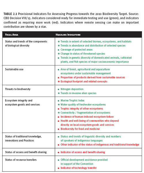
Table 2.1 highlights those areas within the CBD’s current indicator framework (
Decision VIII/15) where remote sensing can make an important contribution to indicators associated with set goals and targets. Within this particular framework, remote sensing has wider application at the national or subnational level than at the global level. Furthermore, there are several global remote sensing measures outside this framework that can be used to discern trends in environmental conditions associated with biodiversity. Phenomena such as surface air and water temperatures, glacial retreat, energy use, and others can be measured successfully via satellite (for practical examples, see
UNEP’s Atlas of Our Changing Environment (2005)).
2.2 What is an indicator?
An indicator can be defined as a measure used to determine the performance of functions, processes, and outcomes over time. Within the context of the CBD, these measures are useful only if they address questions relevant to actual activities or priorities of the Strategic Plan, various programmes of work, or national biodiversity strategies. Furthermore, indicators are feasible only if the data to generate them can be realistically obtained.
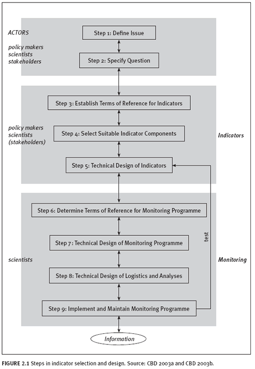
SBSTTA guidelines on designing national-level monitoring and indicators (CBD 2003) offer much practical guidance on the process of indicator development according to the process shown in figure 2.1. They state that indicators should be problem oriented (focusing on human-caused change, not natural fluctuations), simple to understand, and inexpensive enough to be implemented over the long term. The indicators listed by the CBD for testing at a global scale are very broad (for example, “connectivity/fragmentation of ecosystems”), leaving room for different methods of measurement and interpretation. In contrast, indicators used at a national scale should be defined and explained precisely in relation to the key question(s) and policies they are intended to address.
Remotely sensed images do not represent biodiversity indicators per se. Rather, remote sensing data form the raw inputs from which indicators can be constructed. For example, the signal to remote sensors can be associated with a particular vegetation cover type (such as forests). A change in the signal from one time period to another might indicate a change in vegetation cover and the habitat that is associated with that cover. Validation with ground truth or by high resolution data is necessary to confirm remote sensing observations. Data manipulation within a GIS environment can help produce the maps and statistics needed to create an indicator that can be understood by decision makers and the general public.
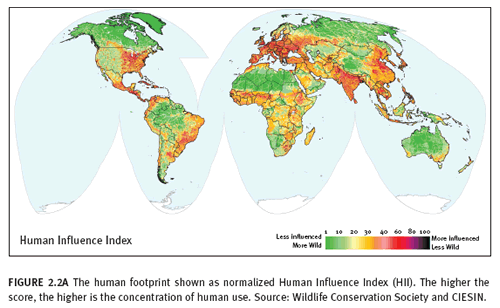
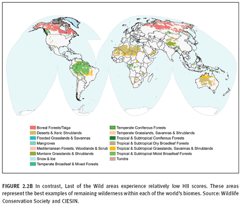
Indicators can be simple, based on single variables, or composite indicators, based on a combination of multiple variables, with the benefits of simplicity versus comprehensiveness. An example of a simple indicator for biodiversity created from remote sensing data might be “area of x land cover (as a surrogate for habitat) over time.” In contrast, a complex indicator is composed of multiple variables and is often represented by an index. Good examples of complex indicators for biodiversity at the global scale are contained within Sanderson et al. State of the Wild (2002). This assessment demonstrated how to combine global data sets on human population density, land transformation (derived from remote sensing), accessibility (distance from major roads, rivers, and coastlines), and electrical power infrastructure to create an index of human influence on land and to map relative wildness (or intactness) at one-kilometre resolution. (See figure 2.2A and B). In addition, the same data were used to identify “wildland seeds” or relatively small areas with low human impact that might be considered important regional nodes of conservation and restoration (not shown).
Wackernagel also created a resource accounting system that tracks human demand on nature, called the Ecological Footprint. Results are published in a number of publications and websites, including
WWF’s biennial Living Planet Report (WWF, Global Footprint Network, Zoological Society of London, 2006). The Footprint is composed of two parts: national Footprint (human demand on nature) and national biocapacity (availability of nature). The system uses as inputs a number of data points that were generated through remote sensing. For example, it uses information from the
Global Agro-Ecological Zones (International Institute for Applied Systems Analysis and Food and Agriculture Organization 2000), which in turn relies on GIS layers of 12 land cover classes produced by remote sensing as one of its primary inputs. The relative productivity of cropland, pasture, forest, and built-up areas is calculated using these data points.
Remote sensing information and resulting indicators may be presented as maps, graphs, or tables, depending on the type of data available, the importance of the spatial pattern of the indicator, and the ease of interpretation to the target audience. Mapped indicators have strong visual impact, and the geographic frame of reference provides context and highlights links that might otherwise not be obvious to many potential users.
2.3 The 2010 target and formation of indicators
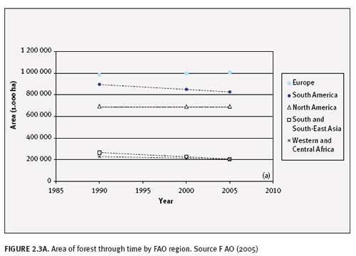
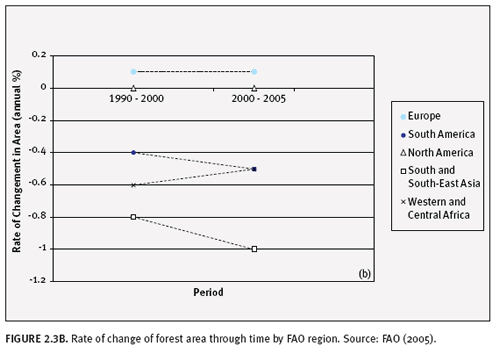
Most indicators represent a defined measurable attribute or condition. Within a monitoring framework they are produced and compared at successive points in time. However, the 2010 biodiversity target specifies a decrease in terms of the rate of biodiversity loss. Therefore, indicator values need to be further translated into rates if they are to measure progress toward the 2010 target. Figure 2.3 illustrates this point, using area of forest values from the
FAO (2005) as an example data set. This data set includes the area of both natural and plantation forests, as assessed by the FAO on the basis of national statistics. If this measure were selected as an indicator of trends in extent of ecosystems, the 2010 target would be to slow the rate of decline in forest area.
Figure 2.3A shows that of the five FAO regions with the greatest forest area in 1990, forest area decreased for both periods measured (1990–2000 and 2000–05) in South America, South and Southeast Asia, and West and Central Africa. Figure 2.3B presents the same data in a form relevant to the target. In the latter figure, a positive slope indicates success in the terms of the target—a decrease in the rate of loss. The data suggest that for the 2000–05 period compared to the 1990–2000 period, there was a decrease in the rate of loss for West and Central Africa, while the rate of loss for both South America and South and Southeast Asia increased. The rate of change for both Europe (including the Russian Federation) and North America was stable, with Europe having a small, steady percentage increase in forest area; there was no change in North America. Thus, three points are required to obtain the minimum two rates of change needed to confirm or deny a reduction in the rate of biodiversity loss.
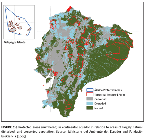
The reality is that few countries have data attained by a consistent method for three dates in a row. However, many countries do have high-quality land cover maps derived from satellite data. Often, these are overlaid with maps of protected area boundaries to determine the degree of protection of different ecosystem types and states (see the example in figure 2.4). Although one or two photographs of land cover cannot yet be considered an indicator of progress toward the 2010 goal, these data may serve as baseline data for monitoring in the future.
2.4 Use of biodiversity indicators in national assessments
The framework and indicators selected by the CBD to assess global progress toward the 2010 biodiversity target provide a starting point for developing indicators for national use. As countries track their own progress toward 2010 and beyond, they may have alternative or additional needs for indicators. These needs are dictated by national and subregional policy priorities, which may differ from the global priorities. Therefore, our discussion of remote sensing indicators will go somewhat beyond those in the current global framework and will touch on a variety of remote sensing measures within each focal area.
In the recent Global Environment Facility–funded project,
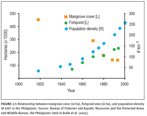
Biodiversity Indicators for National Use (BINU), Bubb et al. (2005) identified useful applications of remotely sensed data in generating biodiversity indicators to address key questions raised at the national scale. In each of the four countries involved in this project, (Ecuador, Kenya, the Philippines, and Ukraine), at least one of the key questions concerned changes in land cover and land use and its effects on biodiversity. One important lesson in all the BINU countries was that although the maps were often useful, they are not always easy for decision makers to interpret, and the conclusions drawn from them as indicators were sometimes ambiguous. Graphical summaries of statistical data drawn from maps can be more useful tools than the maps themselves in some instances. Graphs may especially be less cumbersome in presenting time courses of change in multiple variables. Figure 2.5 shows an example from the Philippines in which long-term data on national mangrove cover, some of which are derived from remote sensing, are plotted alongside data on human population and aquaculture development, two measures of pressure on mangrove ecosystems.
All of the countries involved in BINU found data from remote sensing to be useful in developing biodiversity indicators for national use. However, all countries identified the costs associated with routine updating of satellite-based data to be a major challenge. Another complication for some countries is that many existing map products are derived from imagery obtained by different sensors at different resolutions and often from multiple or unspecified dates or both, thus introducing an unknown amount of error into the results.
Countries participating in BINU found that the capacity to use spatial data to identify, analyse, and interpret decision makers’ key questions was not always available. In addition, collaboration among individuals and groups with a diverse range of skills was vital to ensure that key questions were being adequately addressed and that indicators were being properly assessed and communicated clearly to the target audience. Maps do not act as indicators in and of themselves. Users, therefore, may require assistance in making clear the most important insights made. Sometimes, combining maps with statistical tables and graphs is helpful in accomplishing this goal.
In summary, it is clear from the experience of the BINU project that remote sensing can play an important role in generating biodiversity indicators for national use, but care must be taken to identify the key questions for which indicators are needed and communicate effectively with the decision makers who are expected to use them.
2.5 National-global monitoring linkages
The CBD framework for assessing progress toward the 2010 biodiversity target includes global headline indicators. Ideally, processes at the global, regional, national and local levels would use the same indicators. Such an approach would allow building global biodiversity monitoring information from local, national and regional data. The adoption by the Council of Europe of the CBD indicators into the process
Streamlining European Biodiversity Indicators (SEBI2010) is an example of the synergy that can be produced by aligning indicators. The initiative is finalizing its indicators in 2007, which will be informed by national statistics offices and represent an example of a bottom-up approach to biodiversity monitoring.
However, a perfectly aligned, nested system of parallel indicators is not possible or perhaps even desirable at this time. Specific monitoring needs vary from country to country, many monitoring systems were created before the 2010 framework was designed, and methods for even the same indicators vary from place to place. Therefore, it is not possible to upscale national biodiversity information for global indicators. The only realistic approach is that countries and regional efforts are free to identify and develop their own indicators with regard to their own interests and capacity.
Pereira and Cooper (2006) therefore propose a dual scale approach to the global monitoring of biodiversity with global- and regional-scale programmes at the species and ecosystem levels. The global-scale programmes would follow a top-down approach, with an emphasis on central coordination, consistency and transparency, whereas the regional-scale programmes would follow a bottom-up approach, with an emphasis on regional management needs and capabilities.
The global scale monitoring of ecosystems would entail the production of consistent global land-cover maps based on remote sensing; as well as a global network for monitoring habitats that are best monitored, or have particular relevance, at the regional level (e.g., wetlands, coral reefs). The second edition of
Global Biodiversity Outlook reports on existing global maps on trends in the extent of selected ecosystems and their integrity.
A dual approach is also planned for
FAO’s 2010 Global Forest Resources Assessment. In addition to data provided by countries on the basis of national forest inventories, remote sensing would provide complementary information on the spatial distribution of forests and on forest and land cover and land-use change dynamics at the biome, regional and global level. In most instances, cross-referencing remote sensing data with field assessments can improve the quality and between-year standardization for national assessments also. More often than not, national ecosystem assessments are produced from field estimates. However, by marrying field data with the technological capabilities of remote sensing more area can be covered and more frequently. Given some level of coordination and classification harmonization, ground information and remote sensing results from national assessments would ideally be used to calibrate and validate global models thereby greatly improving our ability to monitor the global state of biodiversity.
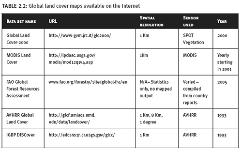
Currently, there are a few global land-cover data sets that contribute to our knowledge of the distribution of ecosystems, and all but one are produced by remote sensing (see table 2.2). However, none of the global datasets are directly comparable with each other as they all come from different satellite systems and/or use different classification systems. The
SPOT and
MODIS products (Bartholomé et al. 2005 and Friedl et al. 2002 respectively) are most promising as they are constructed of finer resolution data that will detect changes in smaller areas. The GLOBCOVER project, an initiative of the
European Space Agency, includes the production of global land-cover maps for the years 2005 and 2010 using a classification system compatible with the GLC 2000. However, it will be based on data from a different sensor (ENVISAT-MERIS) and at a different resolution from GLC 2000. Only through validation can we determine the reliability of change detection between these two datasets.
In an attempt to relate different land cover hierarchies and classifications — such as exist now in many national and global systems — FAO developed the Land Cover Classification System (LCCS) (Di Gregorio and Jansen 2000), which has since been further refined (
FAO 2005). The LCCS represents a comprehensive, standardized a priori classification system, created for land cover mapping and independent of the scale or mapping method. The classification uses a set of independent diagnostic criteria that allow correlation with existing classifications and legends. The system could therefore serve as a reference base for land cover. The methodology is comprehensive in the sense that any land cover identified anywhere in the world can be readily accommodated. Because of the heterogeneity of land cover, the same set of classifiers cannot be used to define all land cover types. The hierarchical structure of the classifiers may differ from one land cover type to another. Therefore, the LCCS has two main phases: 1) an initial Dichotomous Phase, where eight major land cover types are distinguished; and 2) a subsequent Modular-Hierarchical Phase where the set of classifiers and their hierarchical arrangement are tailored to the major land cover type. This approach allows the use of the most appropriate classifiers and reduces the total number of impractical combinations of classifiers. Because of the complexity of the classification and the need for standardization, a software application has been developed to assist the interpretation process. This will reduce inconsistencies between interpreters and between interpretations over time.
2.6 CBD and remote sensing needs
2.6.1 Coordination of scientific and conservation monitoring communities
The recent agreement at the Third Earth Observations Summit to establish a
Global Earth Observation System of Systems (GEOSS) could facilitate and contribute to the monitoring scenario described above. GEOSS will focus on nine societal benefit areas, two of which address biodiversity and ecosystems management and protection. Thus, through GEOSS, there is an open window of opportunity for the scientific and conservation communities to tackle some of the challenges associated with biodiversity monitoring, e.g.: the comparability of existent land-cover data sets, the development of classification systems differentiating natural forest from industrial tree plantations, and assembling useful global remote-sensing data sets for dryland degradation.
2.6.2 Higher accuracy of measurements and classifications
The accuracy of global land cover datasets and global land cover change datasets needs to improve. The collection and distribution of land cover and land cover change validation (ground truthing) data is necessary to guide the classification process and assess the accuracy of the final product. Unfortunately, there remains a lack of international coordination and standardization in this component (Strahler et al. 2006; Wulder et al. 2006). There are several independent efforts collecting and cataloging these data but they are typically not shared. Reasons for not broadly distributing these data include:
Validation data are typically collected for a specific project and are not in a format that is suitable for easy query and use by others. Some projects have no interest in sharing their data possibly to maintain a competitive edge over other researchers. There are no widely accepted standards for the collection, archiving, and distribution of validation data.
This is an area where the conservation community, with their broadly distributed network of project sites, can have a significant impact to support land cover mapping and monitoring. One effort that is trying to accomplish this task is the
Global Integrated Trends Analysis Network (GITAN) which is a network of collaborators interested in understanding the types, causes, and consequences of change on the landscape. A component of GITAN is the System for Terrestrial Ecosystem Parameterization (STEP) database. STEP stores land surface parameters and was designed as a tool for training and validating land cover maps. Two other global scale validation efforts include:
CEOS working group on calibration and validation MODIS land validation
2.6.3 Continuity of data sources
Continuous long term satellite data from a single platform are needed to achieve the highest levels of accuracy for detecting change. Currently, the longest continuous stream of data comes from the Landsat series of satellites, which has been operational since 1972. The three most popular long-running optical satellite programmes, Landsat, SPOT, and IRS are expected to continue well into the future although there will likely be a significant gap in the Landsat acquisitions due to problems with Landsat 7 and delays developing a successor. The continuation of these and other missions into the future is critical for the national and regional monitoring programmes that rely on their data products.
2.6.4 Periodic data buys to release to all those who could not otherwise afford to buy the imagery
Periodic data buys of global wall-to-wall distributions make data economically accessible to developing countries. An example is the
Global GeoCover-Ortho database which resulted from a 1998 contract between NASA and Earth Satellite Corporation (EarthSat) as part of the NASA Scientific Data Buy program. The majority of the data was acquired by the Landsat Thematic Mapper (TM) and Multispectral Scanner (MSS) remote-sensing systems; consequently, the GeoCover-Ortho images are the most accurate freely available satellite-derived base maps of the world. With a positional root mean square error of less than 50 m, they are more accurate than most of the world’s 1:200,000-scale maps. Furthermore, owing to the nature of the original contract set up by NASA, this imagery is more economically accessible for developing countries. It is a comprehensive global data set with image dates ranging from 1970’s to 2002 and is suited to establishing a worldwide environmental baseline. Additional Landsat TM images (and many other types of remotely sensed data) can be overlaid on the
GeoCover-Ortho imagery for purposes of change detection. Subsequently, Landsat Orthorectified Pansharpened ETM+ data were compiled through NASA’s Commercial Remote Sensing Program producing a 15m data set that is available from
EarthSat Corp. for a nominal cost.
2.6.5 Technology transfer
Many countries lack the technology and trained personnel to take advantage of remote sensing for operational monitoring. Technology transfer is needed from those that do, as well as from non-governmental organizations with experience in biodiversity monitoring.
2.6.6 Datasets designed to support the reporting requirements of various environmental treaties and agreements
Datasets should be designed to fit the criteria for more than one environmental agreement when possible. There is an ongoing effort to coordinate CBD reporting requirements with other environmental treaties and multinational environmental agreements such as the Kyoto Protocol, UN Convention to Combat Desertification, Ramsar Convention on Wetlands, and Montreal Process. De Sherbinin (2005) outlines the information needs of these treaties discusses the feasibility of remote sensing for monitoring and assessment as well as other support functions including issue definition, implementation review, compliance, dispute resolution and public education. Remote Sensing in Support of Ecosystem Management Treaties and Transboundary Conservation.
2.7 References
Bartholomé E and A. Belward. 2005. GLC2000: A new approach to global land cover mapping from Earth. International Journal of Remote Sensing 26(9), 1959-1977.
Bubb, P., M. Jenkins, and V. Kapos. 2005. Biodiversity Indicators for National Use: experience and guidance. Cambridge. UNEP-WCMC.
http://www.unep-wcmc.org/collaborations/BINU. (accessed January 20, 2006).
CBD. 2003a. Monitoring and Indicators: Designing National-Level Monitoring Programmes and Indicators. Ninth meeting. Montreal, November 10–14. Item 5.3 of the provisional agenda. Subsidiary Body on Scientific, Technical and Technological Advice, Secretariat of the Convention on Biological Diversity, Montreal, Québec, Canada. UNEP/CBD/SBSTTA/9/10.
http://www.cbd.int/doc/meetings/sbstta/sbstta-09/official/sbstta-09-10-en.pdf (accessed May 22, 2007).
CBD. 2003b. Report of the Expert meeting on indicators of biological diversity including indicators for rapid assessment of inland water ecosystems. Ninth meeting. Montreal, November 10–14. Item 5.3 of the provisional agenda. Subsidiary Body on Scientific, Technical and Technological Advice, Secretariat of the Convention on Biological Diversity, Montreal, Québec, Canada. UNEP/CBD/SBSTTA/9/INF/7.
http://www.cbd.int/doc/meetings/sbstta/sbstta-09/information/sbstta-09-inf-07-en.doc (accessed May 22, 2007).
De Sherbinin, A. 2005. Remote Sensing in Support of Ecosystem Management Treaties and Transboundary Conservation. Palisades, NY: CIESIN at Columbia University. Available online at
http://sedac.ciesin.columbia.edu/rs-treaties/laguna.html.
Di Gregorio, A., and L. M. J. Jansen. 2000. Land Cover Classification System (LCCS): Classification concepts and user manual. Environment and Natural Resources Service, GCP/RAF/287/ITA Africover–East Africa Project and Soil Resources, Management and Conservation Service, Rome. FAO.
EROS Data Center. 2000. Land cover characteristics database, Version 2.0.
http://edcwww.cr.usgs.gov
FAO. 2005. Forest Resources Assessment 2005. Food and Agriculture Organization of the United Nations, Rome, Italy.
http://www.fao.org/forestry/site/fra2005/en (accessed January 29, 2006).
Friedl, M.A., D. K. McIver, J. C. F. Hodges, X. Y. Zhang, D. Muchoney, A. H. Strahler, C. E. Woodcock, S. Gopal, A. Schneider, A. Cooper, A. Baccini, F. Gao, and C. Schaaf 2002: Global land cover mapping from MODIS: algorithms and early results, Remote Sensing of Environment, Vol. 83 (1-2), pp. 287-302.
Hansen, M.C., R.S. Defries, J.R.G. Townshend, and R. Sohlberg. 2000. Global land cover classification at 1 km spatial resolution using a classification tree approach. International Journal of Remote Sensing 21(6/7):1331–64.
IIASA and FAO. 2000. Global Agro-Ecological Zones (GAEZ) 2000 CD-ROM. International Institute for Applied Systems Analysis (IIASA) and Food and Agriculture Organization (FAO), Rome.
Loveland, T.R., B.C. Reed, J.F. Brown, D.O. Ohlen, Z. Zhu, L. Yang, and J.W. Merchant. 2000. Development of a global land cover characteristics database and IGBP DISCover from 1 km AVHRR data. International Journal of Remote Sensing 21(6/7): 1,303-1,330.
Pereira, H. M., and D. Cooper. 2006. Towards the global monitoring of biodiversity change. Trends in Ecology and Evolution 21.3:123–9.
Sanderson, E., J. Malanding, M. A. Levy, K. H. Redford, A. V. Wannebo, and G. Woolmer. 2002. The human footprint and the last of the wild. Bioscience 52(10):891–904.
www.wcs.org/humanfootprint (accessed May 2007).
Secretariat of the Convention on Biological Diversity 2006. Global Biodiversity Outlook 2. Montreal
Strahler, A. H., L. Boschetti, G. M. Foody, M. A. Friedl, M. C. Hansen, M. Herold, P. Mayaux, J. T. Morisette, S. V. Stehman, and C. E. Woodcock1. 2006. Global land cover validation: recommendations for evaluation and accuracy assessment of global land cover maps, EUR 22156 EN. European Union.
UNEP. 2005. One Planet Many People: Atlas of Our Changing Environment. Division of Early Warning and Assessment (DEWA) United Nations Environment Programme UNEP. Nairobi, Kenya
Wulder, M. A., S. E. Franklin, J. C. White, J. Linke, and S. Magnussen. 2006. An accuracy assessment framework for large-area land cover classification products derived from medium-resolution satellite data. International Journal of Remote Sensing 27:663-683.
WWF, Zoological Society of London, Global Footprint Network. 2006. Living Planet Report. Gland, Switzerland, 40 pp.
http://assets.panda.org/downloads/living_planet_report.pdf (accessed 13 June 2007)