Chapter 9. Coverage of Protected Areas
Author:
James Strittholt, Conservation Biology Institute
Contributor:
Peter Leimgruber, Smithsonian National Zoological Park
Reviewers:
Sarat Babu Gidda, Secretariat of the Convention on Biological Diversity
Gary Geller, NASA Jet Propulsion Laboratory
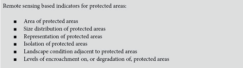
Remote sensing based indicators for protected areas:
9.1 Background
The protected area network (national parks, nature reserves, and other designations) is widely recognized as a crucial tool for protecting global biodiversity; maintaining environmental services; and protecting cultural, aesthetic, and ethical values (Hockings et al. 2000). According to
Article 2 of the Convention on Biological Diversity (CBD), a protected area is “a geographically defined area which is designated or regulated and managed to achieve specific conservation objectives” (CBD 1992). Similarly, the
World Conservation Union (IUCN) defines protected areas as “areas of land and/or sea especially dedicated to the protection and maintenance of biological diversity, and of natural and associated cultural resources, and managed through legal or other effective means” (IUCN 1994). The
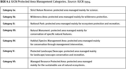
IUCN World Commission on Protected Areas (WCPA) protected area categories are listed in Box 9.1. This system for classifying areas by management objective is viewed as the global standard. Depending on local context, protected areas are faced with a variety of pressures or threats. Some are primarily threatened by human encroachment, others by invasive species, while others are well protected, but isolated from other natural habitats. Many protected areas are faced with multiple stressors. Most extrinsic pressures (e.g., extreme disturbance events or climate change) are very difficult to manage. Some of the more intrinsic ones (e.g., exotic species invasion or degradation by human visitation) can be managed more effectively provided that the managers of the protected areas have enough financial resources and human capacity to address these stressors (Bruner et al. 2004). The WCPA has produced a framework for assessing the effectiveness of protected area management (Hockings et al. 2006). Effectiveness monitoring can be approached by measuring trends in status in the context of the site’s management history and by comparing changes within the protected area with changes in nearby similar ecosystems. Assessment criteria for the protected area status include biological significance, threat, vulnerability, and national context. Many of these can be assessed using techniques outlined in this sourcebook, with the following caveat: an area whose condition has declined may currently be well managed, but there may be a lag between improved management practices and visible improvement in condition. One of the first steps in evaluating protected area status is to identify its/their location(s). The collation of accurate, spatially explicit data on protected areas can be technically and politically challenging. In the worst-case scenario, a given area may lack precise spatial definitions in law or demarcation on the ground. In some countries, a designated area does not enjoy full legal status until demarcation is carried out. The
World Database of Protected Areas (WDPA), managed at the
United Nations Environment Programme World Conservation Monitoring Centre (UNEP-WCMC) in collaboration with the World Database on Protected Areas Consortium, compiles information on the status, environment, and intended management of individual protected areas, including location data. Updates are published annually, and the recorded year of designation, area, and category of each site can be used to summarize trends through time (WDPA Consortium 2005). WDPA is currently finalizing new protected areas system design specifications to improve completeness and accuracy of this ever-changing data theme. The WDPA database is the best available tool for understanding the distribution and extent of protected areas on a global scale, but for individual countries, national data may be more up-to-date and complete at this time.
9.2 Protected area network development
While the extent of a protected area network can be monitored without recourse to remote sensing, remote sensing data can assist in the planning of an expanded network. Such expansion has been recommended both by protected area professionals and by the Conference of the Parties (COP) to the CBD. The
Durban Action Plan (WCPA 2004) emerged from the Fifth IUCN World Parks Congress in 2003, a meeting of protected area professionals participating in the World Commission on Protected Areas. The fourth main target of this plan is, “A system of protected areas representing all the world’s ecosystems is in place by the time of the next World Parks Congress.” Among other points, the plan proposes that quantitative targets be set for each ecosystem by 2008, and that all Red List species are protected in situ, with priority given to critically endangered species confined to single sites.
In February 2004,
CBD COP 7 adopted Decision VII/28 on protected areas, which includes an annexed Programme of Work (CBD 2004). The Programme of Work will be assessed at each COP until 2010 and has the overall objective of “the establishment and maintenance by 2010 for terrestrial and by 2012 for marine areas of comprehensive, effectively managed, and ecologically representative national and regional systems of protected areas that collectively, inter alia through a global network contribute to achieving the three objectives of the Convention and the 2010 target to significantly reduce the current rate of biodiversity loss.”
The Decision requests individual countries to “elaborate outcome-oriented targets for the extent, representativeness and effectiveness of their national systems of protected areas.” The Programme of Work suggests that Parties complete gap analyses and establish protected area targets by 2006.
Decision VII/30 of COP 7 provides a global context, specifying a provisional goal of protection of at least 10 percent of each of the world’s ecological regions.
At a system level, a gap analysis considers the representation of ecosystems or species of conservation interest within the existing protected area network (Scott and Schipper 2006). It may present one or more alternative solutions for modifications to the network to increase their representation. In addition, isolation of protected areas may be addressed by linking them through ecological corridors, such as the
Mesoamerican Biological Corridor and the
Pan-European Ecological Network. Any allocation of new protected areas relies upon multicriteria decision-making and so requires consistent information on biodiversity value, threats, and constraints such as existing land use. A considerable amount of effort has been focused on methods of maximizing the biodiversity represented within the minimum area, at both a network level and an individual site level. More recently, methods for assessing the impacts of climate change have been explored (Araújo et al. 2004). Maps of status and trends in extent of biomes, derived from remote sensing, provide one important input to such analyses. Additional biodiversity data may already be available at a national scale or be sourced from international data sets such as those collated for the Global Amphibian and Mammal Assessments and the
Millennium Ecosystem Assessment.
9.3 Potential role for remote sensing
Remote sensing can play only a very limited role in mapping designated protected areas. Its main and important function is in appraising protected area condition, including the condition of surrounding land. By measuring the biophysical conditions (principally land cover types and human disturbance, including local and regional habitat fragmentation), remote sensing can be useful in assessing management effectiveness of protected areas. Indicators for monitoring protected area status can therefore be derived by spatial overlay of themes such as land cover change (inside and outside protected area boundaries) and various human disturbance layers with the national protected area boundary theme.
At a global scale, remote sensing data have been used to obtain an overview of habitat integrity and degree of conversion within and around protected areas (Defries et al. 2005; Hoekstra et al. 2005). In some countries, a protected areas monitoring system is already in place and may include a strong remote sensing component. In other cases, the emphasis has been on more ad hoc project work. Numerous studies of protected area status and condition have used remote sensing technology (Bock et al. 2005; Curran et al. 2004; Rand 2002; Salami et al. 1999; Vasconcelos et al. 2002). Future coordination of these efforts could provide a powerful monitoring resource as efforts to evaluate overall protected area effectiveness are developed and implemented (Dudley et al. 1999; Courrau 1999; Hockings 2003; Parish et al. 2003).
“Watchful eye” monitoring looks for obvious visual changes in time series of remote sensing images. For example, repeat analysis of satellite imagery for World Heritage sites is being carried out with the support of the European Space Agency, starting with the mountain gorilla habitat of the Virunga Mountains (see
http://www.cotf.edu/ete/modules/mgorilla/mgvirungas.html and UNESCO 2005).
Remote sensing can provide a “coarse filter” or “alarm,” highlighting target areas for more detailed examination (Townshend et al. 2002; Zhan et al. 2002). Protected area monitoring may also be more sophisticated, extracting specific, quantitative indicators.
Multiple studies have been devoted to assessing the role of remote sensing in indicating the location, extent, rate, and sometimes even drivers of changes in and around protected areas (Liu et al. 2001; Sánchez-Azofeifa et al. 2001; Sánchez-Azofeifa 2003). Not only can remote sensing be used to monitor protected area condition, but it can also be used to identify locations outside protected area boundaries that may be better suited for natural resource extraction; however, these findings would require field validation of both suitability and long-term conservation impacts (Kairo et al. 2002). These studies demonstrate that remote sensing alone is not enough to answer every question pertaining to protected area monitoring, but it is an extremely important data resource (as demonstrated in the figures below).
An important source of multitemporal imagery focused on many of the world’s protected areas is
TerraLook (formerly known as the Protected Areas Archive), a project of the
NASA Jet Propulsion Lab. The examples below illustrate the use of remote sensing to address a range of issues in and around protected areas. (These examples were generously provided by TerraLook.)
A land cover change example from TerraLook found in
figure 9.1, which shows the Iguazú Falls National Parks in Argentina and Brazil.
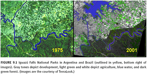
The satellite image on the left was acquired in 1975 and the one on the right in 2001. Major changes have taken place over the 26-year period, both inside and outside the park, including: (1) the construction of the Itaipu Dam on the Paraná River and its resulting large reservoir (top of right image); (2) the sprawl of the twin cities of Ciudad del Este and Foz do Iguazú (left center, just above the intersection of the Iguazú and Paraná rivers); (3) widespread conversion of natural land cover to agriculture; and (4) some return of forest cover along the Brazilian side of the park, north of the Iguazú River.
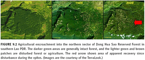 Figure 9.2
 focuses on the northern border of the Dong Hua Sao Reserved Forest in southern Lao People’s Democratic Republic (PDR). In the time series presented (1975, 1989, and 2000), a wave of agricultural encroachment can be seen. The reserve managers knew that some encroachment by coffee farmers might be taking place within this relatively remote portion of the protected area, but they were surprised by the extent of the land cover change shown in the imagery. This imagery also provides an excellent example of the importance of field validation. By the latest image, some apparent recovery from disturbance is observed (marked with a red arrow). The forest canopy has closed here, but it is not clear whether the canopy is formed by coffee bushes or native forest species.
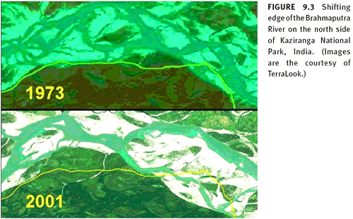
Finally,
figure 9.3 shows two images of Kaziranga National Park in northeast India. The northern edge of the park border lies along the dynamic border of the Brahmaputra River. The dynamic nature of this river, redistributing sediment and altering channels, provides an interesting management challenge. These images from 1973 and 2001 illustrate erosion and deposition patterns that have occurred during this period: the river bank has receded by nearly 2 kilometres in one area and accreted by nearly 3 kilometres in another.
While these examples are mostly visual, the information contained in them can be turned into quantitative indicators. This type of imagery can be used to quantify trends in land cover change, habitat fragmentation, and changes in habitat of selected species. Table 9.1 lists a selection of protected area monitoring issues with which remote sensing can assist. Indeed, remote sensing is sometimes the only effective way to assess a particular issue.
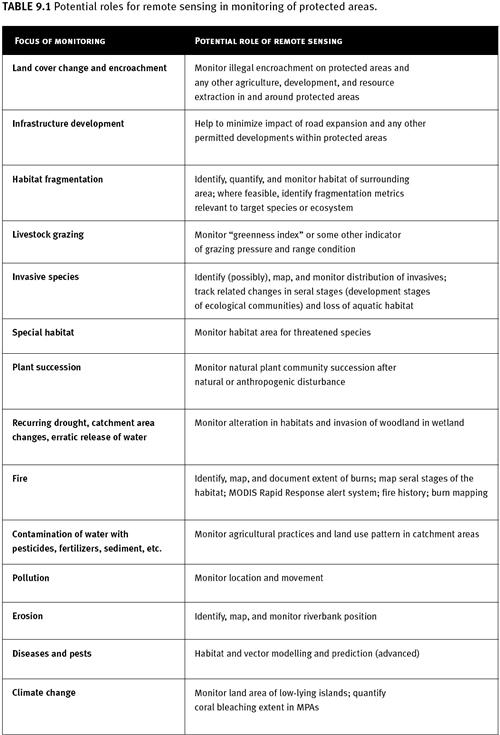
Table 9.1 Potential roles for remote sensing in monitoring of protected areas.
Case study 9.1: Monitoring Land Cover Change in Myanmar’s Protected Areas
Author: Peter Leimgruber
Indicator: forest cover extent and change
Potential monitoring scales: landscapes, small and large nations, global
Sensor: Landsat TM and Landsat ETM+
Imagery cost: free from Internet sites, or up to $600/image from United States Geological Survey (USGS). An orthorectified Landsat data set can be downloaded for free from Global Land Cover Facility at the University of Maryland.
Limitations on accuracy: cloud cover, confusion of forest canopy phenology with human-induced change and vice versa, inaccuracy in protected areas maps.
a. Introduction Myanmar is one of the most forested countries in mainland Southeast Asia. These forests support a large number of important species and endemics and represent the last strongholds for species such as tiger (
Panthera tigris) Asian elephant (
Elephas maximus), Gurney’s pitta (
Pitta gurneyi), and Eld’s deer (
Cervus eldi). Indo-Burman forests are considered a biodiversity hotspot, and protection of representative ecosystems in this region is a priority for global biodiversity conservation. Since 1985, the number of protected areas in Myanmar has increased from 14 to 33. Some analysts estimate current protection to encompass little more than 2 percent of Myanmar’s total land area. Limited resources, personnel, and infrastructure are thought to have limited the effectiveness of many of Myanmar’s parks. A recent countrywide assessment of forest cover and forest cover change conducted by the Smithsonian Institution, based on 1990 and 2000 Landsat images, shows that forest cover has been in slow decline. However, the Smithsonian Institution has identified 10 deforestation hotspots. Most notable were the losses of mangrove forests and dry forests in the central regions of the country. The effectiveness of protected areas in preventing deforestation was assessed using the same methods.
b. Methods Complete coverage of Landsat 5 Thematic Mapper (TM) images for 1989–1992 and Landsat 7 Enhanced Thematic Mapper (ETM+) images for 2000–2001, was acquired for all terrestrial protected areas in Myanmar. All images were registered to NASA’s Geocover, a set of orthorectified images from the 1990s. All of the selected images had been acquired at the end of the monsoon season and the beginning of the dry season, when forest vegetation tends to be lush and cloud cover is low. These factors reduced the confounding effects of seasonal changes in leaf cover in the country’s mixed-deciduous and dry forests. Cloud cover among images used in the analysis was less than 2 percent.
To determine changes in the forest cover of protected areas between 1990 and 2000, an iterative supervised classification technique was used. This integrates multitemporal images and classifies forest cover and forest cover changes in one step. Satellite images acquired during the same seasons in different years are combined into one data set and used in supervised classification. During classification, the analyst identifies homogenous areas of forest cover and forest cover change and derives spectral response statistics for these areas. Based on the spectral responses, the images are then classified into maps depicting forest cover and deforestation. Classification categories were defined as follows:
(1) Nonchange classes: (a) Forest. All closed-canopy tall forests (canopy cover greater than 50 percent; tree height greater than 5 metres feet) observed on both image dates, including most mature forests; also savannahlike dry dipterocarp forests and sometimes forests partially degraded by selective logging or thinning. (b) Water. All water bodies such as oceans, lakes, reservoirs, rivers, and wetlands observed in the ~2000 imagery. (c) Nonforest. All areas that were neither classified as water nor as forest in the ~1990 imagery. (d) No data. All areas obscured by clouds, cloud shadow, and other shadow in one of the satellite images. (2) Change classes: (a) Deforestation. All areas observed as forest in ~1990 and nonforest in ~2000. (b) Reforestation. All areas observed as nonforest in ~1990 and secondary forest in ~2000. (c) Water change. All areas changing from water to nonwater or vice versa.
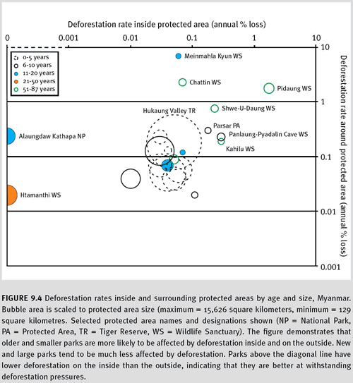
c. Results Myanmar has 24 protected areas that are larger than 100 square kilometres and have more than 40 percent forest cover. Several of these protected areas (n=6) were created before independence from British rule in 1948, but a large number were established after the Nature Conservation and National Parks Project funded by FAO-UNDP in 1983. An almost equal number (n=8) are proposed and may be gazetted in the next few years. Our satellite analysis of remaining forest cover and forest cover conversion revealed that most protected areas still have substantial forest cover, frequently above 90 percent. Several areas have as little as 42 percent forest cover. Annual deforestation rates inside the protected areas generally are below the countrywide average of 0.2 percent, but several areas have higher losses, especially Pidaung, Kahilu, Panlaung-Pyadalin Cave, and Shwe-U-Daung (Figure 9.4). Three of these areas are among the oldest protected areas of the country, indicating that protection over longer time periods may be only moderately successful or that there is a more effective level of conservation planning for newer areas.
Deforestation pressures, measured as the deforestation rate within 5 kilometres of the protected area boundary, are severe for several protected areas, with annual rates well above the countrywide average. These include Pidaung, Shwe-U-Daung, Chatthin, and Meinmahla Kyun (Figure 9.4). In the first two, these pressures have already led to forest loss inside the protected areas, while in the last two, deforestation on the inside was minimal over the study period. In the case of Chatthin, this may be explained by the presence of an international conservation project to preserve endangered Eld’s deer and a well-trained protected area staff. However, Meinmahla Kyun has only recently been gazetted and has few staff. Lack of deforestation inside this area may result from low accessibility.
Overall, Myanmar’s protected areas currently seem to effectively protect closed-canopy forests. Some of the oldest areas have undergone the most deforestation over the 10-year period, but Htamanthi, declared in 1974, has experienced no forest loss. Most of the areas have a low ratio of inside to outside deforestation, indicating that even where pressures outside the park are high, protected areas are often extremely effective.
d. Limitations Using multi-date Landsat images to assess remaining forest cover and forest cover changes in protected areas is a useful and cost-effective analysis to identify problem areas. However, the techniques have several limitations:
- To address progress toward the CBD 2010 target, it would be necessary to assess whether there is a reduction in the rate of change in natural forest cover within protected areas. This would require imagery from more than two dates.
- In addition, 10 years are a short time span over which to evaluate the effectiveness of a protected area. We suggest that longer-term monitoring systems be employed that reach back to the 1980s and map forests in protected areas at five-year intervals.
- A significant portion of the closed canopies mapped in our study may have been secondary forest. The extent of this issue can only be evaluated via extensive ground-truthing.
- The empty-forest problem: Commercial trade as well as subsistence hunting can severely reduce species diversity, even in structurally intact natural forests. Remote sensing and satellite imagery cannot provide a direct measure of these threats and their effect on biodiversity.
- Monitoring the extent of some habitats (e.g., wetlands, natural grasslands) using Landsat satellite imagery is more difficult than is monitoring forest extent.
9.4 Data and other resources
The World Database on Protected Areas (WDPA) This is the most comprehensive dataset on protected areas worldwide and is managed by UNEP-WCMC in partnership with the IUCN World Commission on Protected Areas (WCPA) and the World Database on Protected Areas Consortium. The WDPA is an extensive relational database containing information on the status, environment and management of individual protected areas. The web sites listed below allow query of the database, exploration of the spatial data through an interactive map service, and download of the latest release of the database. Various publications are also available for download.
http://www.unep-wcmc.org/wdpa/index.htm and
http://www.unep-wcmc.org/protected_areas
Terra Look Formerly known as the Protected Area Archive (PAA),
TerraLook distributes collections of satellite images packaged with simple visualization and analysis tools. The images to be included in a collection can be selected by users from a global archive, or a user can obtain one of the “stock” collections. The viewer/toolkit, which is bundled with the image collection, provides simple and intuitive capabilities to allow users to display protected area boundaries and other GIS shape files on the image, adjust and annotate the image so it can be used as a communication vehicle, measure area and distance on the image, compare images taken at different times, and perform other activities useful for conservation.
Protected Areas Learning Network (PALNet) PALNet aims to compile and disseminate protected area management knowledge, with an additional focus on the implications of global change. The large number of documents and project profiles available on the site can be searched or browsed by category.
9.5 References
Araújo, M.B., M. Cabeza, W. Thuiller, L. Hannah, and P.H. Williams. 2004. Would climate change drive species out of reserves? An assessment of existing reserve-selection methods. Global Change Biology 10(9):1618-1626.
Bock, M., P. Xofis, J. Mitchley, G. Rossner, and M. Wissen. 2005. Object-oriented methods for habitat mapping at multiple scales – Case studies from Northern Germany and Wye Downs, UK. Journal for Nature Conservation 13(2-3):75-89.
Bruner, A.G., R.E. Gullison, and A. Balmford. 2004. Financial costs and shortfalls of managing and expanding protected-area systems in developing countries. BioScience 54(12): 1119 — 1126.
CBD. 1992. The Convention on Biological Diversity.
http://www.cbd.int/convention/default.shtml (accessed May 22, 2007).
CBD. 2004. Programme of Work on Protected Areas. Annex to Decision VII/28: Protected areas. Decisions Adopted by the Conference of the Parties to the Convention on Biological Diversity at its Seventh Meeting. UNEP/CBD/COP/7/21.
http://www.cbd.int/doc/decisions/COP-07-dec-en.pdf (accessed May 22, 2007).
Courrau, J. 1999. Monitoring protected area management in Central America: A regional approach. Parks 9 :56-60.
Curran, L., S. Trigg, A. McDonald, D. Astiani, Y. Hardiono, P. Siregar, I. Caniagon, and E. Kasischke. 2004. Lowland forest loss in protected areas of Indonesian Borneo. Science 303(5660): 1000-1003.
Defries, R., A. Hansen, A.C. Newton, and M.C. Hansen. 2005. Increasing isolation of protected areas in tropical forests over the past twenty years. Ecological Applications 15(1): 19-26.
Dudley, N., M. Hockings, and S. Stolton. 1999. Measuring the effectiveness of protected area management. Partnerships for Protection. Eds. S. Stolton, and N. Dudley. London: Earthscan, 249-257.
Hockings, M. 2003. Systems for Assessing the Effectiveness of Management in Protected Areas. Bioscience 53 (9): 828-832.
Hockings, M., Stolton, S. and N. Dudley. 2000. Evaluating Effectiveness: A Framework for Assessing the Management of Protected Areas. Gland, Switzerland and Cambridge, UK., IUCN.
Hockings, M, S Stolton, F Leverington, N Dudley and J Corrau 2006. Evaluating effectiveness : A framework for assessing management effectiveness of protected areas 2nd edition, IUCN WCPA and University of Queensland, Gland Switzerland and Brisbane Australia.
Hoekstra, J.M., T.M. Boucher, T.H. Ricketts, and C. Roberts. 2005. Confronting a biome crisis: Global disparities in habitat loss and protection. Ecology Letters 8: 23-29.
IUCN. Guidelines for protected areas management categories. IUCN World Commission on Protected Areas with the assistance of the World Conservation Monitoring Centre. 1994. Cambridge, UK and Gland, Switzerland.
http://www.unep-wcmc.org/protected_areas/categories/eng/index.html. (accessed December 2005).
Kairo, J.G., B. Kivyatu, and N. Koedam. 2002. Application of remote sensing and GIS in the management of mangrove forests within and adjacent to Kiunga Marine Protected Area, Lamu, Kenya. Environment, Development and Sustainability 4 (2): 153–166.
Liu, J., M. Linderman, Z. Ouyang, L. An, J. Yang, and H. Zhang. 2001. Ecological degradation in protected areas: The case of Wolong Nature Reserve for Giant Pandas. Science 292 (5514 ):98-101.
Parrish, J.D., D.P. Braun, and R.S. Unnasch. 2003.Are we conserving what we say we are? Measuring ecological integrity within protected areas. Bioscience 53 (9): 851-860.
Rand, D. Forest fragmentation near Tai National Park, Ivory Coast. PAMS department, University of Canterbury, Christchurch, New Zealand, 2002.
http://www.cybermagic.co.nz/resources/content/20010822.htm. (December 2005).
Salami, A.T., O. Ekanade, and R.O. Oyinloye. 1999. Detection of forest reserve incursion in south-western Nigeria from a combination of multi-date aerial photographs and high resolution satellite imagery. International Journal of Remote Sensing 20(8):1487-1497.
Sánchez-Azofeifa, G.A., G.C. Daily, A. Pfaff, and C. Busch. 2003. Integrity and isolation of Costa Rica’s national parks and biological reserves: examining the dynamics of land-cover change. Biological Conservation 109:123-135.
Sánchez-Azofeifa, G.A., R.C. Harriss, and D.L. Skole. 2001. Deforestation in Costa Rica: A quantitative analysis using remote sensing imagery. Biotropica 33(3):378-384.
Scott, J.M., and J. Schipper. 2006. Gap analysis: a spatial tool for conservation planning. Principles of Conservation Biology Comp. M.J. Groom, G.K. Meffe, and C. Ronald Carroll. Sunderland, MA: Sinauer. 518-519.
Townshend, J.R.G., R.S. DeFries, X. Zhan, R.A. Sohlberg, M. C. Hansen, C. DiMiceli, M.L. Carroll, and J.C. Eastman. 2002. MODIS 250m and 500m time series data for change detection and continuous representation of vegetation characteristics. Analysis of multi-temporal remote sensing images; Proceedings of the First International Workshop on the Analysis of Multi-temporal Remote Sensing 2001, Trento, Italy. Eds. L. Bruzzone, and P. Smits. World Scientific, London, UK. 233–40.
Vasconcelos, M., J. Mussa, A. Araujo, and M. Diniz. 2002. Land cover change in two protected areas of Guinea-Bissau (1956-1998). Applied Geography 22(2):139-156.
UNESCO. 2005. Space technology to protect mountain gorillas. Media advisory N°2005-21. United Nations Educational, Scientific and Cultural Organization.
http://portal.unesco.org/es/ev.php-URL_ID=26763&URL_DO=DO_TOPIC&URL_SECTION=201.html. (December 2005).
WCPA. The Durban Action Plan. 2004.
http://cmsdata.iucn.org/downloads/durbanactionen.pdf. (October 2005).
WDPA Consortium. 2005. World database on protected areas. World Conservation Union (IUCN) and UNEP World Conservation Monitoring Centre (UNEP-WCMC).
http://www.unep-wcmc.org/wdpa/
Zhan, X., R. Sohlberg, J.R.G. Townshend, C. DiMiceli, M. Carroll, J.C. Eastman, M. Hansen, and R.S. DeFries. 2002. Detection of land cover changes using MODIS 250m data. Remote Sensing of Environment 83: 336-350.