Chapter 5. Trends in Selected Biomes, Habitats, and Ecosystems: Dry and Sub-humid Lands
Authors:
Holly Strand, World Wildlife Fund (WWF-US) and Utah State University
Peter Leimgruber, Smithsonian National Zoological Park
Thomas Mueller, Smithsonian National Zoological Park
Contributors:
Jessica Forest, Wildlife Conservation Society
Eric Sanderson, Wildlife Conservation Society
Peter Coppolillo, Wildlife Conservation Society
Guy Picton Phillipps, Wildlife Conservation Society
G. Gray Tappan, SAIC EROS Data Center
Reviewers:
Jaime Webbe, Secretariat of the Convention on Biological Diversity
Mike White, Utah State University
Remote sensing has been used with varying degrees of success when considering biodiversity indicators in dry and sub-humid lands. Changes in biodiversity are most often represented as habitat or ecosystem conversion (change in extent); changes in habitat or ecosystem quality, including ecological processes; and occurrence and distribution of threats to biodiversity.
5.1 Delineating Cover and Estimating Change in Extent
A single definition for the delineation of dry and sub-humid lands within a monitoring context has yet to be determined. Part I, Article 1 of the
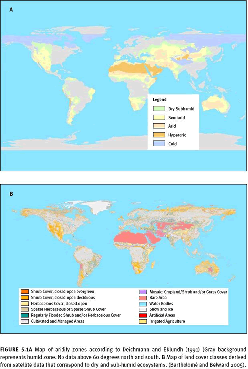
United Nations Convention to Combat Desertification refers to arid and sub-humid lands as areas, other than polar, subpolar, and hyperarid regions, with a ratio of annual precipitation to potential evapotranspiration under 0.65 (UNCCD 1994; Middleton and Thomas 1992). Meanwhile, land cover types measurable by remote sensing correspond more closely to an ecosystem-based definition of dry and sub-humid lands as per the definition adopted by the Convention on Biological Diversity. They include Mediterranean landscapes, grasslands and savannas, and deserts. Figures 5.1a and 5.1b compare the distribution of UNCCD aridity zones with an example of dryland cover types identified by remote sensing. For more information on definition issues for the CBD and UNCCD, see Sörensen (2007).
Other criteria for delineating and categorizing dryland ecosystems include tree cover thresholds (Intergovernmental Panel on Climate Change 2004; Scholes and Hall 1996), vegetation height (for example, Bartholomé and Belward 2005), vertical vegetation complexity (that is, numbers of canopy strata and Hall 1996), disturbance regime (fire or drought et al. 2000), and land use (for example, rangeland and grazing systems 1985, 1993). Some definitions use these factors in combination. Remote sensing has been used to characterize all of these with some degree of accuracy. As with forests, sensors such as VEGETATION, MODIS, and AVHRR that sample the Earth’s surface frequently are useful for distinguishing general patterns of distribution; TM, ETM+, SPOT HRV and HRVIR, IRS LISS, CBERS IRMSS, and Terra ASTER can provide higher-resolution information and more accurate classifications. IKONOS and QuickBird provide the highest resolution but at the highest cost as well.
To date there are no ongoing programmes for monitoring change in the global extent of dry and sub-humid lands. Existing global land cover maps, such as GLC2000 (Bartholomé and Belward 2005), GLCCD (Loveland et al. 2000), and the University of Maryland global land cover classification (Hansen et al. 2000) do not have sufficient resolution or accuracy for either global or regional monitoring needs, although they are useful for establishing approximate area and distribution for one time period. Classifications for these maps are mostly based on associations with the Normalized Difference Vegetation Index (NDVI). Minimum annual red reflectance, peak annual NDVI, and minimum channel three brightness temperature were among the most used metrics for the University of Maryland map. Accuracies hover around 80 percent overall, with most errors in drylands occurring as a result of confusion between grasslands and croplands or grasslands and wooded grasslands. Even if repeated over time, only dramatic changes across large areas or in smaller, well-sampled areas could be detected from these mapping efforts.
5.1.1 Local and regional extent and change General trends in the extent of dryland ecosystems can be examined over time by correlating variables such as reflectance values, principal components, band ratios from multitemporal satellite data such as AVHRR and MODIS with known or estimated values from the field (McDermid et al. 2005). For very small areas, the mapping of individual trees or specific grassland communities might be accomplished using high-resolution satellite data such as IKONOS and QuickBird. However, perhaps the most useful approach for biodiversity monitoring would entail the compromise between cost and accuracy that is achievable at an intermediate resolution with either Landsat or SPOT imagery. Several classification techniques are available for change analysis (supervised or unsupervised, simultaneous or postclassification—see
Chapter 3 on remote sensing basics). Relying exclusively on automated classifications of grasslands and other arid ecosystems is likely to produce less than optimal results. Traditional remote sensing and image interpretation techniques, which rely on visual interpretation of such cues as texture, tone, contrast, and context, are helpful in identifying and delineating individual habitats or ecosystems.
In general, accuracy levels are higher under certain conditions such as a small area of interest, strategic timing of scene acquisitions, more detailed knowledge of ground cover type, greater knowledge of local ecology, and more extensive ground truth information. Furthermore, low turnover in the soil-rock background is preferable for accuracy’s sake. Under such conditions, Grignetti et al. (1997) achieved 85 percent classification accuracy in the Mediterranean and up to 95 percent among finely defined community types such as thermophile oak wood, mixed oak wood and evergreen scrubs,
Pinus pinea woods, and agricultural areas.
5.1.2 General considerations for satellite monitoring in dry and sub-humid lands Many of the same issues that affect the interpretation of satellite measurements in dryland regions hold true for field observations as well; therefore, they are not necessarily shortcomings of remote sensing problems per se. For example, natural transitions between savannas, grasslands, deserts and shrublands, and even forests are often gradual; this makes it difficult to draw boundaries between ecosystems or consistently determine patterns of change when observing from the field, air, or space.
In drylands, considerable natural variation in the spectral qualities of vegetation over time and between seasons makes it difficult to judge when change is significant in terms of biodiversity and natural resource management. Change in vegetation amount is closely linked with variations in local precipitation. Within a single season, storms or rainy periods may result in dramatic localized changes in plant cover. In addition to that of vegetation, spectral characteristics of communities of cyanobacteria, fungi, lichens, and mosses can change in response to such short precipitation events (Tsoar and Karnieli 1996). Ecosystems may experience more than one greenup or variable greenups from year to year (Zhang et al. 2003). Over longer time intervals, irregular events such as periodic droughts, floods or dust storms may have a dramatic effect on the spectral landscape (Muhs and Maat 1993, Schultz and Ostler 1993). These forms of natural variation can be misinterpreted or missed altogether if the timing of acquired imagery is not carefully considered. Meteorological records should be consulted to ascertain moisture conditions associated with a certain satellite image, or to choose optimal dates for a change analysis (Yang et al. 1997; Yang et al. 1998). Global climate data are available from the
Global Precipitation Climatology Project (Adler et al. 2003) and from the
NOAA Climate Prediction Center’s Merged Analysis of Precipitation (Xie and Arkin 1997). However, at 2.5 degree resolution, these data are appropriate for regional use only. Smaller areas, such as landscapes, require a denser set of observations over space and time (Nezlin and Stein 2005). But in many dryland regions, especially in Africa, coverage of meteorological stations is too sparse for regional or local monitoring needs.
One of the biggest challenges for remote sensing in dry and sub-humid areas is that image pixels may contain little or no contribution from photosynthetic plant matter. Instead, soil, shadow, rock, senescent material, or nonphotosynthetic vegetation (NPV) may dominate – this is particularly true in hyperarid areas. It is very difficult to classify or quantify vegetation cover of less than about 40 percent because of the spectral dominance of background soils and rocks (Smith et al. 1990). To reduce this problem, spectral unmixing (mixture modelling) is used to discriminate among soil, nonphotosynthetic material, and plant material. The resulting models of percentage of land cover work reasonably well in certain locales, such as desert shrub canopies (McGwire et al. 2000). However, a significant limitation is that all significant pixel components must have unique and identifiable signatures. Second, the soil-rock background surrounding sparse vegetation may be quite heterogeneous and is unlikely to stay constant across a large area so that reflectance values have to be calibrated frequently throughout. The best results so far have been attained with hyperspectral imagery for very limited areas and when there is vegetation cover over 30% (Okin and Roberts 2004). So, although it holds promise, spectral unmixing is not yet an appropriate technique for operational monitoring.
Monitoring of large dryland regions will require the mosaicking and atmospheric correction of many Landsat images, complicating the analysis process. Images need to be matched at the edges, which can be difficult if they were not taken during the same time period. Broad-scale monitoring, stitching together dozens of Landsat images, has been used for forest monitoring, but we are not aware of efforts for grasslands at the same magnitude. This may be partially due to the fact that it is more challenging to separate grassland from agricultural areas automatically as it requires detailed and time-intensive visual interpretation or the integration of additional data sets. This is a particularly significant limitation in that agricultural expansion is one of the greatest threats to natural dry and sub-humid systems. As a result, studies measuring extent and fragmentation in drylands are likely to be limited in size.
Case study 5.1: Land cover change in Senegal
Author: adapted from Tappan et al. (2004)
Indicators: change in 13 land cover and land use classes
Potential monitoring scale: national, regional, global
Sensors: Landsat TM, ETM+ and Corona
Imagery cost/hectare: free
Limitations on accuracy: sampling vs. complete survey
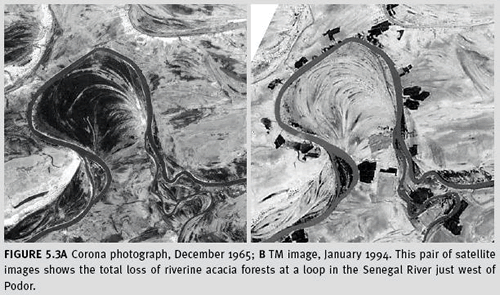
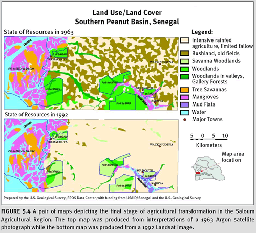
a. Introduction Tappan et al. (2004) analysed and quantified 40 years of land use and land cover changes in Senegal at three points in time—1965, 1985, and 2000. To do so, they used a combination of satellite imagery, aerial surveys, and fieldwork. Imagery was collected from Corona satellite photographs (1965 and 1968 in some cases), Landsat TM (1984–85), and Landsat ETM(+) (1999–2000). Because they started with data from the 1960s, effects of subsequent droughts and the tripling of population could be documented. Ancillary data included 1940s aerial photos from U.S. Army Air Corps, vertical and oblique colour videography, before and after photos taken at 10- to 15-year intervals at hundreds of ground monitoring sites, extensive fieldwork, aerial surveys, and interviews.
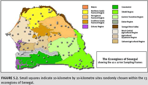
b. Method To cut down on time and cost of interpretation, a sampling scheme was used, consisting of a random sample of 10-kilometre by 10-kilometre frames stratified by ecoregion. Ecoregions are ecological areas with similar biophysical and human management conditions (see figure 5.2). They provide a useful framework for effective research, inventory, and management of natural resources. A total of 9,310 square kilometres was chosen, from 2 to 12 frames per ecoregion equaling 4.6 percent of Senegal’s total land area. Each sample frame was manually interpreted using 13 land use and land cover classes. A manual approach was preferred for working with analogue, film-based photographs. Also, interpreters were able to integrate photographic elements of tone, hue, texture, shape, size, pattern, shadow, and geographic context.
c. Results Tappan et al. summarized the area of each class by ecoregion and by period in time. Results aggregated to the national level show moderate change, with a modest decrease in savannas from 74 to 70 percent from 1965 to 2000 and an expansion of cropland from 17 to 21 percent. However, at the ecoregional scale, they observed rapid change in riparian forests, wooded savannas, and woodlands and a sharp increase in the area of bare, unproductive soil—from 0.3 percent in 1965 to 4.5 percent in 1999. There was an almost complete agricultural transformation of the floristically diverse natural communities in the Saloum agricultural ecoregion. The results of this change assessment have helped Senegal to improve agricultural management, stabilize coastal dunes, protect remaining forest areas, and spread awareness of environmental issues.
5.2 Changes in habitat or ecosystem quality
5.2.1 Degradation and desertification Land degradation or “desertification” of dry and sub-humid areas can result from a number of factors, both natural and anthropogenic (UNCCD 1994). In the context of biodiversity monitoring, we are interested in human-induced changes, which generally result from inappropriate land uses such as intensive tillage, over-irrigation, and overgrazing. These land uses ultimately reduce vegetation and soil productivity through the loss of nutrients, soil organic matter, water-holding capacity, or a combination of these factors.
Relative indices of degradation or condition based on field and auxiliary data (for example, biomass, palatable vegetation, and biodiversity) have been correlated with spectral reflectance values derived from satellite images. Land degradation features associated with wind erosion, salinization, overgrazing, sedimentation, and extreme gullying have been mapped directly in many instances (Lantieri 2003). However, change in vegetation coverage as a result of degradation is more easily detected and interpreted from satellite imagery (Yang et al. 2005) than the various causes of degradation. For example, using TM, existing vegetation maps, and additional field surveys Tong et al. (2004) assessed steppe degradation in Inner Mongolia (China) by tracking gradual changes in the amount of intact
Stipa grandis vegetation and degraded
Artemisisa or
Cleistogenes steppe.
Productivity refers to both the rate of photosynthesis and the rate of biomass accumulation and is a characterization of vegetation that remote sensing can measure reasonably well in simpler canopy structures, such as grasslands or shrublands with sufficient cover (30–40 percent). It is essential that temporal changes in productivity due to degradation are distinguished from natural variability in vegetation in response to climate. It is also important to distinguish between degradation resulting in long-term negative consequences, and the one-time clearing of vegetation.
Productivity trends are commonly derived using the NDVI (Price et al. 2002). The NDVI is calculated as a normalized ratio of the reflectance in the red and near-infrared of the electromagnetic spectrum or NDVI = (NIR — VIS)/(NIR + VIS). The red and near-infrared bands are particularly useful for monitoring vegetation thickness, health, and biomass. In more arid ecosystems, seasonally summed or integrated NDVI values are strongly correlated with vegetation production (Prince 1991; Yang et al. 1998; Wessels et al. 2004). The Enhanced Vegetation Index (EVI), a standard product of MODIS, should be considered in desert or sparse shrub environments where soil contributes significant background reflectance. Kawamura et al. (2005) calculated biomass in the Xilingol steppe in central Inner Mongolia in China using Terra/MODIS EVI. Through regression modelling, they could account for 80 percent variation of live biomass with EVI data. As the MODIS record increases in length, it will become increasingly useful for productivity monitoring.
Long-term study of multi-seasonal and multi-year data (30 to 40 years or more in length) can help characterize the range of normal, natural variation (Dregne and Tucker 1988). At present, the 30-year AVHRR record of the
Global Inventory Mapping and Monitoring Studies (GIMMS) (Tucker et al. 2005) offers the most appropriate data record for studying long-term trends. The high temporal resolution of MODIS will become increasingly useful as the data record lengthens. Data from MSS, TM, SPOT, Kosmos-1939, IRS-IA and IB, and AVIRIS have also been used to assess desertification at finer resolutions (Yang et al. 2005). These data sources with higher spatial resolution but shorter collection histories can be useful for exploring driving factors in areas where degradation is known to occur.
If productivity is observed to diverge from its historical pattern, a number of causes may be considered, such as degradation, conversion to agriculture, increased use of irrigation or fertilizer, initial stages of plant invasion or even climate change (see 5.3.1). Field data and knowledge must be used alongside remotely sensed productivity measures both to calibrate and to validate the cause of change in productivity as well as the effect on biodiversity.
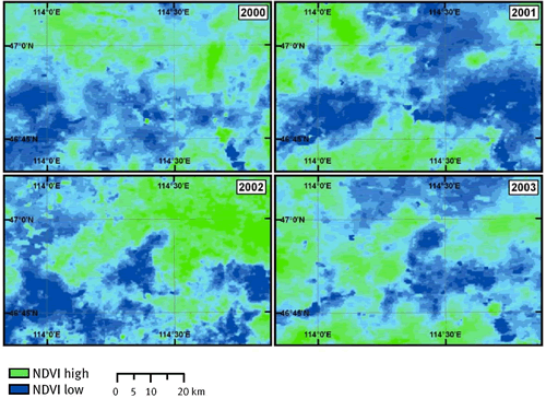 Figure 5.5
 illustrates the considerable natural variation in productivity in Mongolia, which in turn, affects the movements and potential management for wild ungulates. In another example, grass greenness based on the NDVI was used to predict the seasonal movements of wildebeest, hartebeest, and ostrich in the Kalahari of Botswana (Verlinden and Masogo 1997). Pettorelli et al. (2005) provide more detailed explanation and references.
The
Land Degradation Assessment (LADA) of the
Food and Agriculture Organization (FAO) and
United Nations Environment Programme (UNEP) is actively investigating the use of remote sensing for assessing land degradation at the local, national, and global levels for applications related to the UNCCD as well as the CBD. A recent FAO study (Lantieri 2003) on the practicality of remote sensing for monitoring land degradation considers the following functions to be particularly useful:
- to identify trends in vegetation activity, rainfall, soil moisture, and agricultural intensification, all of which can be associated with the desertification process
- to stratify the land surface in order to optimize field sampling for in-depth desertification studies
- to map directly many areas under some specific desertification process (such as wind erosion patterns, salinization patterns (salt may be visible as white patches), overgrazing features shown by low-cover grasslands around animal paths, sedimentation of lakes or rivers (see chapter 7) and large areas of soil water erosion (gullies)
Many experts believe that routine monitoring may be premature in the LADA context. Methods or consensus on how to establish a baseline condition from which to define degradation are still unresolved issues. More information, including the experience of measuring degradation in the countries of China, Senegal, and Australia, is available on
LADA's web site
5.2.2 Ecosystem integrity Dry and sub-humid ecosystems often harbor highly mobile species—especially mammalian herbivores—that are seasonal migrants. Fragmentation or the appearance of unnatural barriers can obstruct migratory movements of such migrants, disrupting their life cycles and ultimately severely reducing their populations (Ito et al. 2005). Their mobile lifestyle generally increases their vulnerability to fragmentation and land use changes (Berger 2004). In some cases migration routes are predictable and have been protected through the alleviation of other pressures, which for example has led to increasing populations of mammalian herbivores in sub-Saharan Africa. In other cases movement routes of populations are variable and difficult to predict which makes them especially difficult to protect (e.g. Mongolian gazelles, Mueller et al. submitted). For issues and methods for detecting and monitoring fragmentation, see chapter 10.
Community intactness might be considered an inverse measure of degradation and represents undisturbed areas with natural levels of biodiversity. Muldavin et al. (2001) found greater richness and abundance of noninvasive and nonruderal plant species to be associated with low-disturbance grasslands with lower shrub abundance, greater litter and grass cover, and less exposed soil. They developed a biodiversity index using TM reflectance values as independent values to predict grass, shrub, litter, and soil cover. As exposed soil and shrub values decrease, litter and grass values increase and, consequently, the biodiversity index goes up. Assuming that biodiversity increased when grass and litter were high and decreased in areas with significant quantities of shrubs or bare ground, a spatial map of biodiversity value results.
Chen et al. (2005) suggest a different method for measuring community intactness in a desert environment. They used Landsat ETM+ data to observe biological soil crusts that consist of communities of mosses, lichens, liverworts, algae, fungi, cyanobacteria, and bacteria. Erosion or inappropriate land use destroys these cryptobiotic crusts, thus their presence and distribution can be an important indicator of desert integrity and biodiversity. Using Landsat ETM+, the authors concluded that if at least 33 percent of a pixel is crust, they can identify it with a Kappa coefficient of 0.82 and overall accuracy of 94.7 percent in a desert environment.
Dry and sub-humid lands feature many ecosystem characteristics whose integrity is not measurable from space. In these cases, field monitoring is more appropriate. For example, many areas support high concentrations of endemic species. This is especially true of Mediterranean landscapes such as the Cape Floral Kingdom of Southern Africa and the Mediterranean Basin. Intact fauna is also not detectable if overhunting has occurred. Therefore, it is important to adopt multiple methodologies in order to develop an accurate picture of biodiversity intactness in any particular place.
5.2.3 Monitoring ecological processes in dry and sub-humid lands Most ecosystems undergo annual or longer-term changes that can be quite dramatic, including green-up, periodic flooding, fires, and droughts. In many cases, these periodic events are part of the natural ecosystem dynamics and should not be considered detrimental to the overall grassland condition. However, as human influence on dry and sub-humid environments increases and climatic changes become more pronounced, there may be an alteration in intensity and frequency of these periodic events, ultimately leading to a degradation of or decline in sensitive ecosystems.
Regular monitoring of natural periodic changes in dry and sub-humid lands is best accomplished at a coarse scale by use of high-temporal-resolution satellite data, such as AVHRR and MODIS, and especially NDVI data sets derived from these images. The techniques are effectively identical to the ones previously discussed, where field-based conditions are related to spectral reflectance using different regression techniques. Again, AVHRR proves to be most useful because NDVI data sets for this sensor date back to the early 1980s, allowing for longer-term time series analysis of climatic, drought, and fire patterns and changes.
MODIS thermal anomalies products (one-kilometre spatial resolution) provide fire data, which are particularly important for grasslands; fire occurrence (day or night), fire location, and an energy calculation for each fire are available and can be used as indicators for drylands where fires, either man-made or naturally occurring, occur frequently. The temporal resolution of this data set ranges from near real-time daily imagery to eight-day and monthly composites. Online sources for fire occurrence information from satellites are described at the end of this chapter.
Case study 5.2: Remote sensing of fire disturbance in the Rungwa Ruaha landscape, Tanzania
Authors: Jessica Forrest, Eric Sanderson, Pete Coppolillo and Guy Picton Phillipps
Indicators: fire occurrence and extent
Potential monitoring scales: landscape, regional, global
Sensor: MODIS
Cost of imagery: free
Limitations on accuracy: cloud cover, heavy smoke, sun glint, fires smaller in area than 100 square metres
a. Introduction The Rungwa Ruaha landscape is a vast area of approximately 40,000 square kilometres, roughly the size of Denmark. This savanna-woodland ecosystem harbors a broad range of wildlife, including hippopotamus (
Hippopotamus amphibious), giraffe (
Giraffa camelopardalis), bushbuck (
Tragelaphus scriptus), as many as 12,000 elephants (
Loxodonta africana), and an intact carnivore guild, including Africa’s third largest population of the critically endangered wild dog (
Lycaon pictus). The Rungwa Ruaha landscape has evolved with fire, emerging from both natural and human causes. Today, most fire in the landscape can be traced to human sources, particularly ecosystem management strategies involving the use of fire, burns set to facilitate hunting, and wildfires emerging from local settlements. We wanted to know whether the amount and patterns of burning change from year to year, from season to season, and according to jurisdiction.
b. Method In order to study patterns of fire in the Rungwa Ruaha landscape, MODIS/TERRA thermal Anomalies/Fire eight-day L3 global one-kilometre grid data were downloaded from the
U.S. Geological Survey (USGS) Web site for the 2000, 2001, 2002, 2003, and 2004 dry seasons (April to December), with an image center point of 35.22 degrees longitude, −5.02 degrees latitude. Using ERDAS Imagine software, images were batch imported and reprojected to UTM Zone 36 North. Flash Renamer 4.62 was used to rename files according to their date of capture. The files were then exported to ArcInfo grid format and further processed, using the Spatial Analyst extension in ArcView 3.2, to construct grid files that indicate whether a given grid cell showed active fire in a given year and during which week(s) the fire occurred. Estimations of area burned by time and jurisdiction were then produced using ArcView. The results are expected to underestimate fire frequency, because the data were not adjusted to take into account cloud cover and no-data values. Such adjustments would have required the incorporation of cloud and missing data information from the daily MODIS/TERRA Thermal Anomalies/Fire data, also available from the USGS, into the estimates.
c. Results Results show the impressive extent of fire activity in the Rungwa Ruaha landscape. In one year, 2004, at least 10 percent of the total landscape burned, and when we looked back over the past five years, we found with remote sensing that nearly 40 percent of the total landscape burned at least once. (See figure 5.6). At the highest end, we found that 60 percent of the Rungwa Game Reserve, an area known for its trophy hunting, had burned in the past five years. Lunda Mkwambi Wildlife Management Area showed the lowest total area burned, at 8 percent. Surprisingly, the national park itself reflected the landscape average for area burned over the past five years, with an estimated area of just under 40 percent. We noted that amount of area burned in each jurisdiction did not appear to be clearly increasing or decreasing over the years, but that there was evidence of interannual
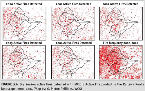
variation in total area affected by fire. We found that in 2003, an area was likely to burn early in the dry season (from April through June) rather than later in the season, from July through December.
d. Limitations There are some limitations to detecting fire activity indicators at coarse scales. When we compared a MODIS image used for our analysis with a higher-resolution Landsat image gathered during the same week, we noted that the area burned (shown by the Landsat image) was in fact larger than the MODIS active fire data indicated (Figure 5.7).
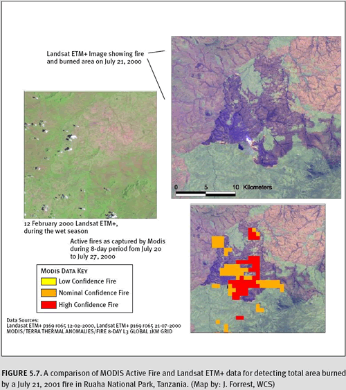
This is because the MODIS satellite, in its orbit, takes snapshots of active fires only two times a day, underestimating the total area affected by the fire. Frequent cloud cover and gaps between image swaths can also lead to underestimates of total area affected; however, fire estimates can be adjusted for these factors. Although it is often possible to underestimate area affected by large and fast-moving fires, both nondetection and overestimation are also at issue. At one-kilometre resolution, the MODIS fire algorithm is capable of detecting only medium- to large-size fires, with smaller fires going undetected. Indeed, ground truth studies suggest that under perfect conditions, the minimum size of a detectable fire is approximately 50 square metres. Perfect conditions are those where the fire is observed at or near nadir on a fairly homogeneous surface, no other significant fires are nearby, and the scene is free of clouds, heavy smoke and sun glint. Under normal, less than perfect conditions, however, larger fires of 100 square metres are detectable only about 50 percent of the time. Once detected, however, these subpixel-scale fires will be overrepresented by one-kilometre grid cells (University of Maryland 2005). A final limitation is that the MODIS Active Fire product does not provide information on fire intensity, which has obvious implications for ecosystem regeneration and biodiversity. Intensity information can, however, be derived from the raw multispectral data itself (Kaufman et al. 2003). It is also possible to estimate fire intensity from environmental information, such as time of year and day, greenness index (or NDVI derived from satellite imagery), precipitation, temperature, wind speed, soil moisture, and vegetation type (Systems for Environmental Management 2005).
Phenology refers to seasonal changes in organisms—such as leafing out, flowering, or senescence—in relation to climate. Phenologic changes in vegetation are easily observable in dry and sub-humid ecosystems when appropriate temporal resolution of satellite imagery is used. Examples of phenological indicators include start of growing season, end of growing season, length of growing season, length of dormancy, or date of maximum plant maturity. The NDVI or some other index of vegetation amount is typically used to determine phenological information. Periodic temporal changes in vegetation phenology, such as greening up and senescence throughout the year, can be used to classify certain ecosystem types with known phenological patterns.
Examples of phenological indicators include start of growing season, end of growing season, length of growing season, length of dormancy, or date of maximum plant maturity; these are all characteristics which can be observed on the ground. Meanwhile, remote sensing measures land surface phenology. The exact relationship between remotely sensed land surface phenology and plant or vegetation phenology cannot be universally generalized; therefore, White and Nemani (2006) recommend that land surface phenology be described as an integration of changing patterns in snowmelt, soil wetness and vegetation development and other processes.
Significant changes in land surface phenological patterns may indicate that conversion or invasion has occurred. Shifting of phenological patterns over time can provide evidence of climate change.
Yu et al. (2004) demonstrated interannual variations of the grassland-desert boundaries in the Gobi Desert by looking at the presence or absence of the onset of green-up. In contrast to grassland environments, the desert showed no measurable green-up in spring. The desert margin displayed a steppe-like phenological pattern in a wet year and a desert-like pattern in a dry year demonstrating the difficulty of classifying such areas when using images from a single time period. In another example, Peters et al. (1997) were successful in differentiating grass from shrub and from grass-shrub mix based on phenological patterns in New Mexico.
5.3 Occurrence and distribution of threats to biodiversity
The CBD Programme of Work on the biological diversity of dry and sub-humid lands mentions a number of pressures on biodiversity. Some of these—such as climate change, fragmentation, overgrazing, and agricultural conversion—produce conditions that can be observed from space. Fragmentation and alien species are discussed more thoroughly in chapters 10 and 11; climate change and overgrazing are discussed in this section.
5.3.1 Climate change Long-term changes in temperature and rainfall patterns can have serious impacts on the biological diversity of dry and sub-humid lands. Because rainfall information is not collected at a sufficiently fine resolution in most parts of the world, many consider it useful to turn to the NDVI as a proxy for rainfall. Several authors have made the link between climate change and long-term increases in the NDVI (Gray and Tapley 1985; Tucker et al. 1985; Townshend and Justice 1986; Nicholson et al. 1990; Tucker et al. 1991; Tucker and Nicholson 1999).
The
GIMMS eight-kilometre, 15-day composite at maximum value is the best existing satellite-derived data set for monitoring climate change using the NDVI (Tucker et al. 2004). Anyamba and Tucker (2005) used this data set to illustrate variation and trends in vegetation and precipitation in the Sahel. Using an established relationship between precipitation and the NDVI, Tucker and Nicholson (1999) found that the NDVI reflected drought conditions during the 1980s and then higher, greener values from the 1990s to 2003. Although they observed year-to-year and decadal variations, there was no evidence of a systematic increase in desertification. Thus, climate and permanent land cover change in the Sahel were not substantiated for this 23-year period on the basis of the remotely sensed record. Osborne and Woodward (2001) applied this relationship to Mediterranean shrublands, observing a long-term increase in the NDVI from 1981 to 1991. They attributed this change to a rise in both precipitation and atmospheric carbon dioxide based on validation using a mechanistic model of vegetative growth and a database of observed climate.
The establishment of the relationship between NDVI and rainfall variation led to the remote sensing drought monitoring and the development of famine early-warning systems (Henricksen and Durkin 1986, Tucker and Choudhury 1987, Hutchinson 1991, Gonzales 2002). Famine is likely to increase unsustainable use of scarce natural resources, thus it is conceivable that famine or drought predictors double as a warning system for potential biodiversity loss as well as for human suffering.
5.3.2 Overgrazing Changes in evolutionary levels of grazing intensity and selectivity will inevitably change biodiversity. Undergrazing and overgrazing can both have negative effects, but overgrazing by livestock is generally more problematic throughout dry and sub-humid lands. Vegetation indices have often been used to document reduced levels of productivity associated with overgrazing as well. NDVI in particular has been used to measure bush encroachment associated with grazing. In Botswana, degraded areas include those suffering from bush encroachment, a result of heavy cattle grazing over a number of years. Using Landsat MSS, Yool et al. (1997) found that replacement of grasslands by woody species was possible. In a study with contradicting results Moleele et al. (2001) note the limitations of NDVI in terms of browse or woody biomass vegetation. Gibbens et al. (2005) demonstrated the utility of combining historical and satellite records to show changes in community type associated with grazing. They mapped reconstructions of historical data produced in land surveys around 1900 and compared them to aerial photos from 1996. They estimated a 20 percent increase in area dominated by creosote bush, tarbush, and especially mesquite and a decrease from 19 percent to 1.2 percent of dominant native black grama. An overabundance of cattle is suspected to be the main cause. The work of Pickup et al. (1998) in central Australia has shown associations between ground cover and vegetation cover indices derived from Landsat MSS and TM. They describe how trends in rangeland condition can be monitored by looking at changes over time in the pattern or vegetation growth across gradients of differing grazing intensity. Vegetation growth was assigned remotely sensed vegetation index values before and after large rainfalls. A vegetation ratio was derived by comparing areas less than four kilometres from water (shown to be an area of intense grazing) with low grazing benchmark areas farther away. Systematic changes in this ratio constitute a trend. Where the ratio decreases over time, the grazing gradient is intensifying and the landscape is degrading. Where the ratio increases, the landscape is becoming more resilient and the grazing gradient is disappearing.
5.3.3 Land use change The most common type of conversion in dry and sub-humid lands occurs in cropland. A sudden shift from natural area to active agriculture can be relatively easy to detect by satellite in deserts. Crops generally have low reflectance in the visible—and high reflectance in the NIR—parts of the spectrum; desert plants feature brighter visible reflectances and lower NIR reflectances (Okin and Roberts 2004, Okin et al. 2001, Ehleringer and Bjorkman 2005). These differences, together with the shape and spatial pattern of patches of crops, often help to differentiate them from other land cover types. However, in grasslands, crops such as wheat or rye often cannot be differentiated unless sufficiently high spatial resolution allows for the detection of crop rows and field borders. Activities such as tillage, planting, and harvest of crops can create rapid seasonal changes in reflectance patterns; therefore, phenological profiles derived from remote sensing data are useful indicators of change. Delineation of changed areas can be assisted by, and may require, knowledge of crop calendars to guide remote sensing data selection and interpretation.
5.3.4 Invasive alien species Effective management of invasives requires accurate knowledge of their spatial distribution and density. Invasive plants with phenological patterns or spectral signatures distinct from the surrounding landscapes make good candidates for remote sensing detection. Dense growth patterns also improve detection accuracy. In most drylands, the lack of an upper canopy facilitates the detection of invasion by remote sensing. Aerial photography has been useful for monitoring invasives in relatively small areas. It is especially useful for riparian invasion given the linear nature of rivers and streams. See Everitt et al. (2001) for an example of how
Tamarix chinensis has been mapped in the American southwest using aerial photography. Hyperspectral imagery increases the odds of finding unique spectral signatures. Using AVIRIS at an altitude for 20 x 20 m pixel size and a threshold value of 10 percent coverage per pixel, Parker and Hunt (2004) predicted the occurrence of leafy spurge with an overall accuracy of 95 percent. Coarser scale satellite data can be used to detect invasives. However, there is a decrease in accuracy and therefore feasibility for monitoring. Bradley and Mustard (2005) investigated cheat grass, an invasive annual with higher interannual variability than native vegetation. An amplified response outside 95 percent confidence interval for native changes in NDVI was used to indicate cheat grass. Upon validation, it was shown that NDVI-TM accurately identified 72 percent of cheatgrass cover while AVHRR identified 64 percent. For more information on monitoring invasives,
see chapter 11.
5.4 Data and other resources
MODIS NDVI/EVI MODIS data are best suited for the monitoring of large areas that may exhibit interannual and annual changes in vegetation cover. Two useful and publicly available data sets based on MODIS imagery are NDVI and EVI which are compiled as biweekly mosaics. The compilation reduces problems from cloud cover and provides a short enough time period to avoid missing major phenological changes. The data can be downloaded at no charge from
NASA’s Earth Observing System (EOS) Data Gateway.
Fire Occurrence and History Fire data, including one- and eight-day composites showing fire anomalies, are compiled from MODIS data and are available at
http://edcdaac.usgs.gov/modis/dataproducts.asp. The European Space Agency’s
ATSR World Fire Atlas provides monthly global fire maps from 1995 to the present.
Global Inventory Modeling and Mapping Studies (GIMMS) The GIMMS NDVI data set represents the best available long-term global record of the normalized difference vegetation index. The NDVI is a measure of vegetative greenness that has been correlated with environmental observations associated with productivity and land cover. Data are available from two online sources:
http://ltpwww.gsfc.nasa.gov/gimms/htdocs/ and
http://glcf.umiacs.umd.edu/data/gimms/
Land Degradation Assessment in Drylands (LADA) The
LADA project develops and tests effective assessment methodologies for land degradation in drylands using a variety of tools, including remote sensing. The ultimate goal is to help the global community improve policies and implement international agreements and conventions such as the UNCCD and CBD. This partnership based effort is led by GEF, UNEP, FAO, and the Global Mechanism of UNCCD. This site includes a report on the Potential Use of Satellite Remote Sensing for Land Degradation Assessment in Drylands (Lantieri 2003) and results from pilot assessments in China, Argentina and Senegal, which have already integrated remote sensing into their measurement activities.
United States Geological Survey Digital Spectral Library Researchers at the
Spectroscopy Laboratory have measured the spectral reflectance of hundreds of materials in their lab and compiled a spectral library. The libraries are used as references for material identification from remote sensing images.
Climate Data Sets Global climate data are available from the
Global Precipitation Climatology Project (Adler et al. 2003) and from the CPC Merged Analysis of Precipitation (Xie and Arkin 1997). However, at 2.5 degree resolution, these data are appropriate for regional use only. Smaller areas, such as landscapes, require a denser set of observations over space and time (Nezlin and Stein 2005).
5.5 References
Adler, R. F., G. J. Huffman, A. Chang, R. Ferraro, P. Xie, J. Janowiak, B. Rudolf, U. Schneider, S. Curtis, D. Bolvin, A. Gruber, J. Susskind, and P. Arkin. 2003. The Version 2 Global Precipitation Climatology Project (GPCP) Monthly Precipitation Analysis (1979-present). Journal of Hydrometeorology. 4:1147–67.
Anyamba A., and C. J. Tucker. 2005. Analysis of Sahelian vegetation dynamics using NOAA-AVHRR NDVI data from 1981–2003. Journal of Arid Environments 63:596–614.
Bartholomé, E., and A. S. Belward. 2005. GLC2000: a new approach to global land cover mapping from Earth. International Journal of Remote Sensing 26:1959–77.
Berger, J. 2004. The last mile: How to sustain long-distance migration in mammals. Conservation Biology 18 (2): 320–331.
Bradley B. and J. Mustard. 2005. Identifying land cover variability distinct from land cover change: Cheatgrass in the Great Basin. Remote Sensing of Environment 94: 204–213.
Chen, J., M. Y. Zhang, L. Wang, H. Shimazaki, and M. Tamura. 2005. A new index for mapping lichen-dominated biological soil crusts in desert areas. Remote Sensing of Environment 96:165–75.
Convention on Biological Diversity. 2005 Decision VII/2 on the Biological Diversity of Dry and Sub-Humid Lands.
http://www.cbd.int/doc/decisions/COP-07-dec-en.pdf
Deichmann, U., and L. Eklundh. 1991. Global digital data sets for land degradation studies: A GIS approach. GRID Case Study Series No. 4, UNEP/GEMS and GRID, Nairobi.
Demaria, M. A, W. J. McShea, K. Koy, and N. O. Maceira. 2003. Pampas deer conservation with respect to habitat loss and protected area considerations in San Luis, Argentina. Biological Conservation 115:121–30.
Dregne, H. E., and C. J. Tucker. 1988. Desert encroachment. Desertification Control Bulletin 16:16–19. Ehleringer, J.R., and O. Björkman. 2005. Pubescence and leaf spectral characteristics in a desert shrub, Encilia farinosa, Oecologia, 36:151-162.
Everitt J.H., D.E. Escobar, M.R. Davis. 2001. Reflectance and image characteristics of selected noxious rangeland species. Journal of Range Management 54:A106–A120.
Gibbens, RP, R.P. McNeely, K.M. Havstad, R.F. Beck, B. Nolen. 2005. Vegetation changes in the Jornada Basin from 1858 to 1998. Journal of Arid Environments 61: 651–668.
Gonzales, P. 2002, Program to monitor impacts of desertification and climate change in Africa, Famine Early Warning System Network (FEWS NET), U. S. Geological Survey
Gray, T., and B. D. Tapley. 1985. Vegetation health: Nature’s climate monitor. Advances in Space Research 5(6):371–7.
Grignetti, A., R. Salvatori, R. Casacchia, and F. Manes. 1997. Mediterranean vegetation analysis by multi-temporal satellite sensor data. International Journal of Remote Sensing 18(6): 1307–1318
Hansen, M. C., R. S.Defries, J. R. G. Townshend, and R. Sohlberg. 2000. Global land cover classification at 1 km spatial resolution using a classification tree approach. International Journal of Remote Sensing 21(6):1331–64.
Henricksen, B.L., and J.W. Durkin. 1986. Growing period and drought early warning in Africa using satellite data. International Journal of Remote Sensing 7 (11):1583–1608.
Hutchinson, C.F. 1991. Uses of satellite data for famine early warning in sub-Saharan Africa. International Journal of Remote Sensing 12(6):1405–1421.
Intergovernmental Panel on Climate Change. 2004. Good practice guidance for land use, land-use change and forestry.
http://www.ipcc-nggip.iges.or.jp/public/gpglulucf/gpglulucf.html (accessed August 2008)
Ito, T. Y., N. Miura, B. Lhagvasuren, D. Enkhbileg, S. Takatsuki, A. Tsunekawa, and Z. Jian. 2005. Preliminary evidence of a barrier effect of a railroad on the migration of Mongolian gazelles. Conservation Biology 19: 945–48.
Kaufman, Y. J., C. Ichoku, L. Giglio, S. Korontzi, D. A. Chu, W. M. Hao, R. R. Li, and C. O. Justice. 2003. Fire and smoke observed from the Earth Observing System MODIS instrument—products, validation, and operational use. International Journal of Remote Sensing 24(8):1765−81.
Kawamura, K., T. Akiyama, H. Yokota, M. Tsutsumi, T. Yasuda, O. Watanabe, G. Wang, and S. Wang. 2005. Monitoring of forage conditions with MODIS imagery in the Xilingol steppe, Inner Mongolia. International Journal of Remote Sensing 26:1423–36.
Lantieri, D. 2003. Potential use of satellite remote sensing for Land Degradation Assessment in Drylands. Application to the LADA Project, FAO, Rome.
http://lada.virtualcentre.org/eims/approver/pub_dett.asp?pub_id=92920&app=0§ion=method (accessed July 2006).
Loveland, T. R., B. C. Reed, J. F. Brown, D. O. Ohlen, Z. Zhu, L. Yang, and J. W. Merchant. 2000. Development of a global land cover characteristics database and IGBP DISCover from 1 km AVHRR data. International Journal of Remote Sensing 21:1303–30.
McDermid, G. J., S. E. Franklin, and E. F. LeDrew. 2005. Remote sensing for large-area habitat mapping. Progress in Physical Geography 29(4):449–74.
McGwire, K. L., T. Minor, and L. Fenstermaker. 2000. Hyperspectral mixture modeling for quantifying sparse vegetation cover in arid environments. Remote Sensing of Environment 72(3):360–74.
McNaughton, S. J. 1985. Ecology of a grazing ecosystem—the Serengeti. Ecological Monographs 55:259–94.
McNaughton, S. J. 1993. Grasses and grazers, science and management. Ecological Applications 3:17–20. Middleton, N. J., and D. S. G. Thomas, eds. 1992. World atlas of desertification. 2nd ed. London: Edward Arnold.
Millennium Ecosystem Assessment, 2005. Ecosystems and Human Well-being: Biodiversity Synthesis. World Resources Institute, Washington, DC.
Moleele, N., S. Ringrose, W. Arnberg, B. Lunden, C. Vanderpost. 2001. Assessment of vegetation indexes useful for browse (forage) prediction in semi-arid rangelands. International Journal of Remote Sensing 22(5):741 – 756.
Mueller T., K. Olson, P. Leimgruber, G. B. Schaller, M. G. Murray, and T. K. Fuller. Submitted for publication. In search of forage: Predicting dynamic habitats of migrating Mongolian gazelles using satellite estimates of biomass productivity. Journal of Applied Ecology.
Muldavin, E. H., P. Neville, and G. Harper. 2001. Indices in grassland biodiversity in the Chihuahuan Desert ecoregion derived from remote sensing. Conservation Biology 15:844–55.
Muhs, D. R., and P. B. Maat. 1993. The potential response of Great Plains eolian sands to greenhouse warming and precipitation reduction on the Great Plains of the U.S.A. Journal of Arid Environments 25:351–61.
Nezlin, N. P., and E. D. Stein. 2005. Spatial and temporal patterns of remote sensed and field-measured rainfall in southern California. Remote Sensing of Environment 96(2):228–45.
Nicholson, S. E., M. L. Davenport, and A. R. Malo. 1990. A comparison of vegetation response to rainfall in the Sahel and East Africa, using Normalized Difference Vegetation Index from NOAA AVHRR. Climate Change 17:209–41.
Okin, G. S., and D.A. Roberts. 2004. Remote sensing in arid regions: Challenges and opportunities. In Remote sensing for natural resources management and environmental monitoring: manual of remote sensing, vol. 4, 3rd ed., ed. Susan Ustin. NJ: John Wiley & Sons.
Okin, G.S., W.J. Okin, B. Murray, and D.A. Roberts. 2001. Practical limits on hyperspectral vegetation discrimination in arid and semiarid environments, Remote Sensing of Environment, 77:212-225.
Osborne, C. P., and F. I. Woodward. 2001. Biological mechanisms underlying recent increases in the NDVI of Mediterranean shrublands. International Journal of Remote Sensing 22(10):1895–1907.
Parker, A.E. and E.R. Hunt, Jr. 2004. Accuracy assessment for detection of leafy spurge with hyperspectral imagery Journal of Range Management. 57:106-112.
Peters, A., M. K. Eve; E. H. Holt, and W. G. Whitford. 1997. Analysis of desert plant community growth patterns with high temporal resolution satellite spectra. Journal of Applied Ecology 34(2):418−32.
Pettorelli, N., J. O. Vik, A. Mysterud, J. M. Gaillard, C. J. Tucker, and N. C. Stenseth. 2005. Using the satellite-derived Normalized Difference Vegetation Index (NDVI) to assess ecological effects of environmental change. Trends in Ecology and Evolution 20(9):503-510.
Pickup, G. G.N. Bastin, and V.H. Chewings. 1998. Identifying trends in land degradation in non-equilibrium rangelands. Journal of Applied Ecology. 35: 365-377.
Price, K. P., X. Guo, and J. M. Stilles. 2002. Optimal Landsat TM band combinations and vegetation indices for discrimination of six grassland types in eastern Kansas. International Journal of Remote Sensing 23:5031–42.
Prince, S. D. 1991. Satellite remote sensing of primary production: comparison of results for Sahelian grasslands 1981–1988. International Journal of Remote Sensing 12:1301–12.
Scholes, R. J., and D. O. Hall. 1996. The carbon budget of tropical savannas, woodlands, and grasslands. In Global change: effects on coniferous forests and grasslands, SCOPE 56, ed. A. K. Breymeyer, D. O. Hall, J. M. Melillo, and G. I. Agren, 69–100. Chichester, United Kingdom: Wiley.
Schultz, B. W., and W. K.Ostler. 1993. Effects of prolonged drought on vegetation association in the northern Mojave Desert. In Wildland Shrubs and Arid Land Restoration Symposium, Las Vegas, Nevada, October 19–21, 1993, ed. B. A. Roundy, E. D. McArthur, J. S. Haley, and D. K. Mann, 228–35. General Technical Report INT-GTR-315. Ogden, Utah: U.S. Department of Agriculture, Forest Service, Intermountain Research Station.
SEM (Systems for Environmental Management). 2005. Fire.org: Public domain software for the wildland fire community.
http://fire.org/index.php?option=content&task=section&id=2&Itemid=25 (accessed September 22, 2005)
Shoshany, M. 2000. Satellite remote sensing of natural Mediterranean vegetation: a review within an ecological context. Progress in Physical Geography 24(2):153–178
Smith, M. O., S. L. Ustin, J. B. Adams, and A. R. Gillespie. 1990. Vegetation in deserts: I. A regional measure of abundance from multispectral images. Remote Sensing of Environment 31:1–26.
Sörensen, Levke. 2007. A spatial analysis approach to the global delineation ofdryland areas of relevance to the CBD Programme of Work on Dry and Sub-humid Lands, Cambridge, UK: UNEP-WCMC. Page: 24
http://www.unep-wcmc.org/habitats/drylands/dryland_report_final_HR.pdf (accessed May 2007)
Tappan, G. C., M. Sall, E. C. Wood, and M. Cushing. 2004. Ecoregions and land cover trends in Senegal. Journal of Arid Environments 59(3):427–62.
Tong, C., J. Wu, S. Yong, J. Yang, and W. Yong. 2004. A landscape-scale assessment of steppe degradation in the Xilin River Basin, Inner Mongolia, China. Journal of Arid Environments 59:133–49.
Townshend, J. R. G., and C. O. Justice. 1986. Analysis of the dynamics of African vegetation using the Normalized Difference Vegetation Index. International Journal of Remote Sensing 7:1555–70.
Tsoar, H., and A. Karnieli. 1996. What determines the spectral reflectance of the Negev-Sinai sand dunes. International Journal of Remote Sensing 17:513–26.
Tucker, CJ; Choudhury, BJ 1987. Satellite Remote Sensing of Drought Conditions Remote Sensing of Environment 23 (2):243-251.
Tucker, C.J, H. E. Dregne, and W. W.Newcomb, 1991: Expansion and contraction of the Sahara desert from 1980 to 1990. Science, 253: 299–301.
Tucker, C.J., Justice, C.O., Prince, S.D., 1986. Monitoring the grasslands of the Sahel 1984–1985. International Journal of Remote Sensing 7:1571–1581.
Tucker, C. J., W. W. Newcomb, and H. E. Dregne. 1994. AVHRR data sets for determination of desert spatial extent. International Journal of Remote Sensing 15:3547–65.
Tucker, C. J., W. W. Newcomb, S. O. Los, and S. D. Prince. 1991. Mean and inter-annual variation of growing-season Normalized Difference Vegetation Index for the Sahel 1981–1989. International Journal of Remote Sensing12:1133–5.
Tucker, C. J., and S. E. Nicholson. 1999. Variations in the size of the Sahara Desert from 1980 to 1997. Ambio 28:587–91.
Tucker, C.J., J.E. Pinzon, M.E. Brown, D. Slayback, E.W. Pak, R. Mahoney, E. Vermote and N. El Saleous. 2005. An Extended AVHRR 8-km NDVI Data Set Compatible with MODIS and SPOT Vegetation NDVI Data. International Journal of Remote Sensing 26 (20) pp. 4485-4498.
Tucker, C. J., J. R. G. Townshend, and T. E. Goff. 1985. African land-cover classification using satellite data. Science 227 (4685):369–75.
UNCCD. 1994. United Nations Convention to Combat Desertification.
http://www.unccd.int. (Accessed August 2008)
University of Maryland. 2005. Web Fire Mapper FAQs.
http://maps.geog.umd.edu/faq.asp (accessed on August 2008.)
Ustin, S. editor. 2004. Remote Sensing for Natural Resources Management and Environmental Monitoring: Manual of Remote Sensing, 3 ed., Vol. 4 ed. NJ: John Wiley & Sons, Inc
Verlinden A., and R. Masogo. 1997. Satellite remote sensing of habitat suitability for ungulates and ostrich in the Kalahari of Botswana. Journal of Arid Environments 35(3):563−74.
Wessels, K. J., S. D. Prince, P. E. Frost, and D. Zyl. 2004. Assessing the effects of human-induced land degradation in the former homelands of northern South Africa with a 1 km AVHRR NDVI time-series. Remote Sensing of Environment 91:47–67.
White, M. and Nemani, R. 2006. Real-time monitoring and short-term forecasting of land surface phenology. Remote Sensing of Environment 104: 43-49.
White, R. P., S. Murray, and M. Rohwedder. 2000. Grassland ecosystems. Washington, D.C.: World Resources Institute. Xie, P. and P. Arkin. 1997. Global precipitation: A 17-year monthly analysis based on gauge observations, satellite estimates, and numerical model outputs. Bulletin of the American Meteorological Society 78:2539–58.
Yang, L., B. K. Wylie, L. L. Tieszen, and B. C. Reed. 1998. An analysis of relationships among climate forcing and time-integrated NDVI of grasslands over the US Northern and Central Great Plains. Remote Sensing of Environment 65:25–37.
Yang, W., L. Yang, and J. W. Merchant. 1997. An assessment of AVHRR/NDVI-ecoclimatological relations in Nebraska, USA. International Journal of Remote Sensing 18(10):2161–80
Yang, X., K. Zhang, B. Jia, and L. Ci. 2005. Desertification assessment in China: An overview. Journal of Arid Environments 63:517–31.
Yool, S. R., M.J. Makaio, and J.M. Watts. 1997, Techniques for computer-assisted mapping of rangeland change. Journal of Range Management 50:307–314.
Yu, F., K.P. Price, J. Ellis, J.J. Feddema, and P. Shi. 2004. Interannual variations of the grassland boundaries eastern edges of the Gobi Desert in central Asia. International Journal of Remote Sensing 25(2):327–46.
Zhang, X., M. A. Friedl, C. B. Schaaf, A. H. Strahler, J. C. F. Hodges, F. Gao, B. C. Reed, and A. Huete. 2003. Monitoring vegetation phenology using MODIS. Remote Sensing of Environment 84:471–75.